In search of ancient Islay
Three very amateur archaeologists set off in search of a variety of features shown on the Ordnance Survey map off what is known locally as the 'back road' to Gruinart. We were so amateur that we did not really know what the words in fancy writing indicated: - 'hut circles', 'burnt mounds' and 'tumuli' all had to be looked up and pages printed off from Scotland's Places website before we ventured forth into the unknown at Lagstoban 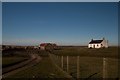 . For once I wasn't after gaining new gridsquares as I had already 'bagged' these. I was, however, constantly checking my GPS to ensure we knew exactly when we'd reached the sites in question, the terrain often presenting some 'false alarms!'
A herd of cows at Lagstoban meant a complicated detour round Loch Meadhon 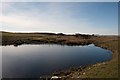 . We paused to admire an old ruin west of Lagstoban
 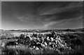 and from there it wasn't far to the hut circle
 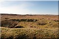 which was really quite obvious when you knew what to look for
 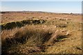 . The hut circle was last visited by The Royal Commission on the Ancient and Historical Monuments of Scotland, who said that 'This is a hut circle on level ground in a area of early modern land use. It measures 8.3m by 7.0m within a wall 0.7m high and spread to 2.5m broad; substantial stone is visible in the general turf cover. The entrance is in the east arc on the longer axis.
Just off the north exterior of the hut is an open-ended enclosure, rectangular to rounded in shape, measuring 7.0m NW-SE by 6.5m over a wall reduced to a turf-covered rubble spread 2.0m wide by 0.4m high. Near the hut circle is walling of probable contemporary land use, but as it occurs within later cultivation, no field pattern is apparent.
Then it was on to the tumuli which I'm afraid turned out to be a bit of a disappointment. We saw several 'tumuli' possibilities before we saw the real ones - slightly elevated mounds in the grassland 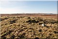 . Last surveyed in 1984 the tumuli or barrows 'lie 26m apart on Cnoc nan Nathrach. The larger is 9.3m in diameter and 0.7m high; and the smaller 4.5m in diameter and and 0.4m high.
Two probable ditched bowl barrows, situated on the crest of a low, broad turf covered knoll at approximately 30m OD.
A: NR 2982 6462 The larger, has overall measurements as stated, with only superficial disturbance to its top, and the crop mark of a 0.5m wide silted ditch surrounding it. A linear east-west field bank curving around its southern half appears a later feature.
B: NR 2583 6465 The smaller, dimensions as stated, again has a cropmark of a 0.5m wide ditch. Its eastern half is badly mutilated, exposing a small stone core with compacted earth capping.
Surveyed at 1:10000
Visited by OS (J R L) 8 May 1978.
On the broad summit of Cnoc nan Nathrach there are two barrows situated 26m apart, the larger measuring 9.3m in
diameter and 0.7m in height and the smaller 4.5m in diameter and 0.4m in height. Both of them have been
disturbed.
RCAHMS 1984' (Information from Scotland's Places website)
After this tiny walk we strolled back to the car where we picked up our lunch things and set off up the Borichill track to examine the fort. This proved extremely interesting. The fort is situated on top of Borichill Mor 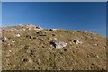 . Scotland's Places records 'The dun on Borichill Mor is roughly circular, with a diameter of 100ft to 130ft. There is much exposed stone on the S and W side. A cairn occupies the summit.
M L Davies 1959.
The top of Borichill Mor is also the site of an ornamental tower, built about 150 years ago (ie. about 1730). Local informants can remember when much of it was standing, but it has been demolished and the best stones removed. The name "Borchill" (sic) is said to have originally applied to the fort.
Name Book 1878.
On the summit of Borichil Mor are the scant remains of a fort measuring about 36.0m NW-SE by 27.0m internally. The wall is traceable for most of the periphery as a robber trench accompanied by a light scatter of rubble core material; on the west side are several massive outer facing stones. A transverse slab in the south-west arc probably indicates the north side of an entrance. A modern cairn occupies the highest point of the hill; there are no certain remains of the ornamental tower noted on Name Book.
Surveyed at 1:10 000.
Visited by OS (N K B) 19 April 1979; Information from RCAHMS to OS.
Little now survives of a small fort situated 3.3km NW of Bridgend on the summit of Borraichill Mor, a prominent hill which affords panoramic views over much of Islay. The immediate approach to the site is over gentle slopes on all sides except the S, where there is a rocky scarp. The dilapidated condition of the fort was probably caused by the construction of an ornamental tower on the hilltop in the early 18th century; about a hundred years later the tower was demolished, and the site was stripped of its stone.(Ordnance Survey Name Book 1878) In spite of the damage, however, the course of the fort wall, which enclosed an oval area measuring about 36m by 27m, can still be traced almost throughout its original circuit, appearing for the most part as a robber-trench accompanied by a light spread of rubble core-material; but the few massive outer facing-stones, measuring up to 1.8m by 0.6m by 0.6m, that remain in situ, as indicated on the plan, suggest that it was a very substantial structure. A transverse slab on the SW probably represents a part of the rw side-wall of the entrance-passage.
RCAHMS 1984
We certainly appreciated the panoramic views afforded from the summit of this modest hill before turning to gaze eastwards at the very prominent hut circles 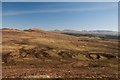 which we descended to examine at closer quarters and found a myriad tiny lichens adorning the banks of these erstwhile dwellings.
With one more destination I clutched my GPS and negotiated tussocks and burns until we arrived at my first ever (knowing) burnt mound (probably a cooking area - very likely with all these ancient dwelling places dotted round the vicinity). 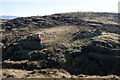 Again, Scotland's Places records 'At NR 3164 6452, on the south bank of a stream, is a burnt mound. It is crescentic, the open end facing onto the stream, and measures some 9.0 by 11.0m across and 1.3m high. Probing of the heather overgrowth reveal an admixture of black earth and friable fragments of reddened stone. There are hut circles in the general neighbourhood.
This would almost certainly have gone unnoticed by the previous Becky (oblivious to ancient history whilst totally immersed in natural history). I shall certainly have my eyes wider open whilst reading the terrain in future! It proved a very interesting, if short, walk.
- When
- Tue, 5 Mar 2013 at 18:57
- Grid Square
 NR3164
blog comments powered by Disqus