A visit to the derelict former RAF Yatesbury air base
It was one of those spur-of-the-moment decisions that have consequences. That Saturday morning, 6th December 2014, I was off to the annual Christmas Fayre in Devizes, and because the weather was bright and frosty, I decided to make the most of the petrol and go for a walk on my way back.
I decided on Yatesbury because it was more or less on my route, and because, when I looked at my worn-out OS map covered in pink highlighter, I realised to my surprise that there were grid squares there that I hadnt geographed yet, quite a few of which were up for TPoints and third or fourth visitor points.
I have visited Yatesbury many times. One winter, I walked through Yatesbury every Sunday on a route from Broad Hinton to Avebury, but this didnt take me near the former air base. But Id been near it on other walks, and the space near a concrete blockhouse close to the junction of The Avenue and the lane to Nolands provides a handy parking spot for walkers. While there, Id seen the old buildings on the other side of the road. I knew they had something to do with the war, but Id taken no interest in them. Another geographer, Brian Robert Marshall (BRM), had no doubt already covered them: such things were right up his street, so I left them to him. But instead of starting my walk in Yatesbury, I decided to do a circular walk starting from a layby not far from the Beckhampton roundabout on the south side of the A4.
Following a track that was once the original London-Bath road through a beautiful beech plantation 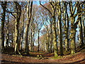 , I soon emerged at the top of Knoll Down, from where I could see Yatesbury Field spread out to my right down below. I continued for some way along the ridge, until I reached a round barrow that I wanted to photograph. From a distance, I could see a concrete slab protruding from the top of it and a kind of concrete gully coming out of the side. Coming closer, I saw that the concrete in the gully had partly fallen down and it was blocked with weeds, which prevented me from exploring it further. I had no idea what this concrete affair was for, assuming that some farmer had put it there, perhaps as a shelter for lambs, though why he should damage a scheduled monument, I couldnt think. I took some photos and moved on
 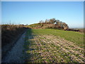 .
.
From the ridge, I could see Yatesbury air strip 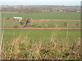 . The windsock told me it was still in use, but I saw no planes taking off, and dismissed it as just another of the tiny leisure airfields in which Wiltshire abounds.
I was now heading in the direction of Cherhill monument, but at the junction of the track that leads to the Iron Age fort on top of the hill, I turned right to cross the A4 and take the minor road to Yatesbury. Just after the bend in the lane, there were a few buildings that looked as if they might be leftovers from the war, but I hadnt sufficient interest to photograph them. This is a lesson I am constantly failing to learn: that you should photograph everything that sparks your curiosity, even if you dont know what it is at the time. They lay beside a drive which was barred by a Private sign, and looked as if they had been commandeered for use as farm buildings.
Just past this point, I could see the derelict buildings of the former RAF Yatesbury camp in the distance across the fields  . If I had never noticed them before, it was because whenever I had come this way before, it was by car. Now, they looked really interesting: since joining geograph, I have become very interested in derelict buildings, which I consider to have a certain sort of beauty, and a ghostly sort of fascination. Looking at my map and realising that they werent accessible from the Jugglers Lane bridleway, I toyed with the idea of cutting across the fields by way of what I took to be a track. But it turned out on closer examination to be just a field boundary, so I scrapped the idea.
Further down the lane, and nearing the right-hand bend for Yatesbury village, I could see Hangar 45, a huge redbrick building which I took to be one of the wartime hangars restored 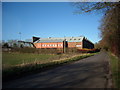 . It was in immaculate condition. The gate was locked, and although it was a Saturday, I could hear a vehicles engine running inside. I took some pictures, both of the side and the offices at the back, feeling sure that it had been covered before (and later being proved right), and continued on to the crossroads, where I turned left into Jugglers Lane.
To my right were the concrete blockhouse and the patch of empty ground which dog-walkers use for parking. The high metal barriers that had once surrounded the blockhouse were now partly torn down. I didnt photograph the blockhouse because it looked too ugly (another mistake), and I was sure BRM had already done so. It did cross my mind to wonder why metal security fencing had been erected, though, but I didnt bother to pursue the thought.
On the other side of the road, the derelict corrugated iron building seemed to have decayed very much since my last visit. Now there was hardly anything left of it. But as I said, I dismissed it as uninteresting and in any case was sure BRM had already recorded it.
I thought I would go down Jugglers Lane a little way, to see if I could get a better view of the derelict buildings I had seen from the road. I walked along an avenue of very tall trees 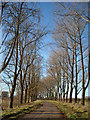 until I came upon a pillbox
 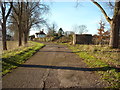 which I didnt remember seeing when I last passed this way a very long time ago. It had all its orifices blocked with concrete. Despite being pretty sure that BRM would have beaten me to it, I photographed it just in case, and continued a short way along the lane.
I should explain that there are two tracks running in parallel from the crossroads as far as the pillbox. The one I was on is metalled, while the other is not. It is the other lane that carries the bridleway past the back of the buildings I was approaching, first of which was a large white house which was clearly lived in. I continued along the metalled lane, but just before the house it was blocked by a gate with a Private sign on it.
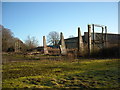
To my left, I could see the derelict buildings of the air base. The one nearest was in a terrible state of disrepair and seemed to be on the point of collapse. It looked as if it might have been a hangar 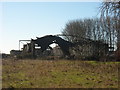 , but the roof beams had partly fallen in, and whatever had covered the roof was now missing, leaving the skeletal frame open to the elements. There was a wide band of rough ground to the left of the lane, so I crossed far enough over this to take some photos, making sure I regained the metalled lane before I was spotted.
Back at the crossroads, I continued towards Yatesbury, taking a photo of the Rectory 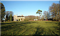 as I passed in case I needed it to bag my grid square, then I continued my walk back to my car.
The following day, I uploaded the photos that would need least research in order to tick off more grid squares and secure more points of one kind or another. Later in the week I began to upload the photographs which required more research, and I came up with quite a few surprises. The first was that the concrete thing in the round barrow on top of Knoll Down turned out not to be something installed by a farmer, but was in fact an anti-aircraft emplacement built during the Second World War. Link![]() That figured: the round barrow stood on the highest part of the ridge, with a good view for miles both to the north over the Yatesbury plain with its airfield, and to the south over the Marlborough Downs, whence enemy aircraft would have approached from the sea. I wondered if the MoD had had to put in a request to alter the scheduled monument (it had been scheduled in 1925). Perhaps it already had a big gouge dug into the top by the antiquaries of the 19th century, although Wiltshire and Swindon Historic Environment Record makes no mention of the notorious Dean Merewether, and gives no references prior to aerial photographs taken in 1946. While excavating the barrow prior to installing the gun emplacement, fragments of human bone and shale and pottery were found, including a Bronze Age beaker. Link
That figured: the round barrow stood on the highest part of the ridge, with a good view for miles both to the north over the Yatesbury plain with its airfield, and to the south over the Marlborough Downs, whence enemy aircraft would have approached from the sea. I wondered if the MoD had had to put in a request to alter the scheduled monument (it had been scheduled in 1925). Perhaps it already had a big gouge dug into the top by the antiquaries of the 19th century, although Wiltshire and Swindon Historic Environment Record makes no mention of the notorious Dean Merewether, and gives no references prior to aerial photographs taken in 1946. While excavating the barrow prior to installing the gun emplacement, fragments of human bone and shale and pottery were found, including a Bronze Age beaker. Link![]()
The second surprise was that the dilapidated hangar I had photographed had originally been built during the First World War. Not only that, but it was Grade II* listed. For those who dont know, many of the most beautiful houses in England only have Grade II listing: to attract Grade II* listing, a building has to be very special indeed. Yet this hangar was practically disintegrating, and looked as if it wouldnt last another winter. What had been going on to merit all those high metal fences and streamers of black plastic flying in the wind, yet resulting in the apparent complete abandonment of the site?
As I looked into it more, I discovered that there were three Grade II* listed hangars on the site, including the wreck of a building that I had seen opposite the parking space at the beginning of the drive, and that there had been two air bases, the East and the West Camps, both going back to 1916. I came across some videos on YouTube made by John Grech Link![]() Link
Link![]() Link
Link![]() (collections of photos really) of the derelict buildings in the camp, and was fascinated by the eeriness of the place which must once have been teeming with life. From one of these, I discovered that the blockhouse at the junction had been the main guard room for the West Camp. I looked again at BRMs photograph: he had described it as a blockhouse, so not having a photograph of my own to upload, I put in a suggestion for a change to his description, which he accepted
(collections of photos really) of the derelict buildings in the camp, and was fascinated by the eeriness of the place which must once have been teeming with life. From one of these, I discovered that the blockhouse at the junction had been the main guard room for the West Camp. I looked again at BRMs photograph: he had described it as a blockhouse, so not having a photograph of my own to upload, I put in a suggestion for a change to his description, which he accepted 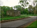 .
.
The third surprise explained why the site looked as if builders had downed tools one day and gone home, leaving it to rot, with the metal fences falling down, the hangar roofs falling in, and not even taking their scaffolding planks away with them.
It appeared that a Moroccan businessman by the name of Jamal Khanfer had bought the site in 1998 and planned to convert the former air base buildings into luxury houses and flats, and to build five new houses to the north of the site. Link![]() According to his agent Mike Milton, from Milton Architects in Marlborough, Khanfer had bought the site to use for flying before he realised the history behind it. After a lengthy public enquiry, his proposals for development were accepted and he started work, but his plans were thwarted in 2008 when, after the financial crash, his funding was pulled, and work ceased. Although by then he had conserved one hangar of the western pair, he clearly had not provided adequate protection from the elements for the other. (Im not sure whether he owns the eastern hangar). In March 2014, he re-submitted his plans for developing the site Link
According to his agent Mike Milton, from Milton Architects in Marlborough, Khanfer had bought the site to use for flying before he realised the history behind it. After a lengthy public enquiry, his proposals for development were accepted and he started work, but his plans were thwarted in 2008 when, after the financial crash, his funding was pulled, and work ceased. Although by then he had conserved one hangar of the western pair, he clearly had not provided adequate protection from the elements for the other. (Im not sure whether he owns the eastern hangar). In March 2014, he re-submitted his plans for developing the site Link![]() but since they did not include proposals for the future use of the conserved hangar, revised plans were requested. In the meantime, although he was served by English Heritage with an Urgent Works Notice to arrest further decline in the condition of the derelict western hangar, before the works were implemented there was a substantial roof collapse. English Heritage, seeing that it is beyond repair, has now given permission for its demolition. Link
but since they did not include proposals for the future use of the conserved hangar, revised plans were requested. In the meantime, although he was served by English Heritage with an Urgent Works Notice to arrest further decline in the condition of the derelict western hangar, before the works were implemented there was a substantial roof collapse. English Heritage, seeing that it is beyond repair, has now given permission for its demolition. Link![]()
I dont know what made me sadder, Khanfers neglect or English Heritages failure to protect the hangar. But that would have been the end of the matter as far as I was concerned had it not been for another suggestion Id made for one of BRMs photos while Id perused those he had uploaded for RAF Yatesbury. BRM had contended that the trees in the avenue leading away from the guard room were oaks 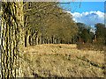 , but I was sure they were not, and suggested beeches. BRM responded that as no-one could be certain unless they went back there in the summer and identified them from their leaves, and until then he was sticking to his description. The moderator weighed in, saying they were not beeches, because beeches had smooth bark, and suggested ash. This was on the Thursday. It must have been on my mind all day Friday, because when Saturday dawned fine and bright, I decided to go back to Yatesbury and find out. It may have been nearly midwinter, but at least I could guess from the buds on the twigs and the leaves and seeds on the ground what the trees were. Not only that, but I wanted to go back and get a better photograph of the gun emplacement in the round barrow, and if possible, get a closer look at the ruined RAF base.
So I set off on Saturday morning and, parking in the same layby as before, made my way swiftly up to the round barrow 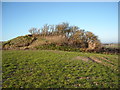 . This time, I pushed my way past the nettles and rubble and into the gun emplacement itself
  . There was another surprise: a little bunker behind the emplacement
 , where I imagined the soldiers sheltering from the cold on long winter nights, with what looked like a fireplace too
  , though realistically, the bunker may simply have been used to store ammunition.
When I emerged from the bunker, I looked out over to the south, from where the bombers would have arrived, and thought of those men keeping their spirits up through many a night on that freezing spot on the Downs. I thought how brave they were, and how much we owe to them. I looked in the other direction over the modern Yatesbury airfield, and as if to make my imaginings real, a small plane took off, banked around and flew over the Knoll.
I went back to the car and drove on to Yatesbury, where I parked opposite what I now knew to be the main guardroom for the West Camp 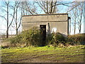 . No longer just an ugly blockhouse, it had become the place where sentries would have stood and challenged everyone who wanted to go along the lane. One iron gatepost still remained of the gate which they would have guarded
 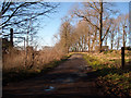 . I took a picture of a hump in the ground behind it, and only realised was a Stanton air raid shelter when I came to upload the photo later
 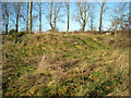 .
.
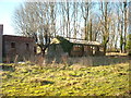
My first priority was to have a good look at the hangar nearest the junction. This was in terrible condition. Even though I had never paid it much attention previously, I noticed that it was in a far worse state than on my visits prior to 2014. I clearly remembered a reasonably solid wall clad with green corrugated iron. Now most of it had disappeared, leaving a few of what looked like huts at ground level and some glassless windows above. The roof was entirely missing.
I was able to get a very close look at what was left of the building and wander round inside it. The vast concrete floor remained, with the iron groove for the hangar doors 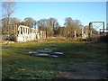 , and the ancillary buildings on either side, but apart from that, it was just a shell of the building
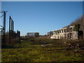
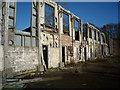
 . How sad that it had survived two world wars and been listed by English Heritage, and yet in the last few years had perished through sheer neglect!
I walked a little way along what used to be the runway, which extended west in the direction of the other hangars and buildings of West Camp. From there, I could see the hangar I had photographed the previous week more clearly, and also the other hangar in the listing, which was black and looked remarkably intact. I desperately wanted to get closer and have a good look, and contemplated walking along the field boundary. But the ground was very rough, and I might have been seen and stopped, so I decided to return to last weeks viewpoint and try to get a better picture from there.
I set off along the lane, looking at the trees as I went. What were they? They definitely werent oaks I could tell that from the shape. They werent beech: the lack of coppery beech leaves and beech nuts beneath my feet made that clear. But they werent ash either: they didnt have those typical black ash buds. I could see no seeds of any kind lying on the ground but I picked up a leaf. It was more or less triangular, roughly like the ace of spades in shape. I put it in my rucksack together with a twig to take home and identify later.
Further down the lane, I took another look at the pillbox, which was a hexagonal Type 22 pillbox. The reason for its position here now became clear: its purpose was to defend the northern perimeter of the West Camp and to protect it from anyone who might have managed to get past the guardroom.
Next I walked over into the rough grass again to try to get a better photograph of the dilapidated hangar. I took some shots with the feeble zoom on my camera, but these turned out to be no better than the shots I had taken the previous week. Besides which, I could see cars parked outside the white house, one of which had its engine running, and I did not wish to be seen. Id decided that I would try to get into the site from further along Jugglers Lane, and if I was seen now, that would put an end to my plan. Normally, I dont so much as deviate from a public footpath, but when as site is as interesting as this, I am prepared to trespass if necessary. If I am seen, I apologise, and sometimes find that the subterfuge was unnecessary; but this time, I was determined to get photos of this site by hook or crook, and I didnt want to jeopardise my chances from the outset.
So I retreated to the pillbox. From there, the public bridleway follows the track to the north of it. I passed with the house on my left, and followed a trimmed hedge and fence for a short distance until it gave way to wilder hedgerows beyond. I could glimpse the camp over to my left but the bushes were too dense for me to get through.
A little further on I came upon another pillbox hidden in the bushes 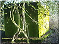 that BRM had missed. It was another Type 22 hexagonal box, but this time the loopholes hadnt been blocked up and you could see that they were of TF744 066 pattern. Link
![]() The whole pillbox was covered in moss which glowed bright green in the afternoon sunshine.
The whole pillbox was covered in moss which glowed bright green in the afternoon sunshine.
And then, eureka! Just beyond the pillbox was a well-worn path through the hedge, over a broken-down barbed wire fence, and across the adjacent rough field towards the camp. I had found my way in!
I get the same thrill from trespassing as I did when I was a child nearly sixty years ago. There is the feeling of butterflies in the stomach at the possibility of getting caught, and the burning excitement to see what you came to see before you are spotted. It is as if a primeval hunting instinct kicks in, and yet you know that as long as you are careful, you are doing no real harm, apart from possibly annoying somebody. And being an adult, you are less likely to take unnecessary risks and put yourself in danger (though I did have some warning shots fired in my direction once), which is partly why I didnt enter any of the buildings.
But before I go on, here is an outline of the history of the camp:
In 1916, the Royal Flying Corps developed two airfields at Yatesbury specialising in training Corps Reconnaissance pilots. Two camps were established, one on each side of the minor road from the A4 to the village itself: this one, the West Camp, comprised the officers and mens quarters with the usual facilities and three large hangars, while the East Camp was adjacent to the A4, where the present airstrip is, and had hangars and workshops. The airfields opened in November 1916 with No. 55 Reserve Squadron arriving from Filton, equipped with the Avro 504A and the Scout D.
Although the war ended in November 1918, training continued into 1919, when squadrons were sent to Yatesbury to be disbanded. The Station finally closed in early 1920, and the land was returned to its original owners and reverted to farmland until 1936.
In 1935, Bristol Aeroplane Company (BAC), which had been operating a school at Filton in Bristol since 1923, purchased part of the former western airfield and built a flying school, which opened in early 1936. This was the No.10 Elementary and Reserve Flying Training School (Wing Commander Guy Gibson VC trained here in 1936). Various facilities were built including an officers mess and accommodation blocks. In 1939 the airfield was taken over by the Air Ministry and brought up to wartime standards, which included the construction of the Bellman and Blister hangars, the Stanton air raid shelters, and a Sommerfield Track of steel mesh matting which was laid on the two runways. Training was carried out with Tiger Moth aircraft. This continued until the outbreak of war in September 1939, when pilot training was transferred away to other stations to allow the field to be used for training airborne wireless operators.
Meanwhile, in 1938/9 on the site of the East Camp, the RAF, realising that it would need a large number of radio operators, built the No. 2 Electrical and Wireless School, (later renamed No. 2 Radio School). The theory of wireless and Morse code were taught on the ground and Dominie and Proctor aircraft were used for the aerial training. The trainees were billeted in a large number of wooden huts; over 50,000 men successfully passed out of the school between 1939 and 1945. In 1942 a heavily guarded compound was built at the eastern end of the camp to teach the new top-secret radar. This was originally known as No. 9 RDF School but was later called the No. 9 Radio School. Over 19,000 men and women were trained there.
At the end of the war air training largely ceased, and the camp was used for basic training for a while. The Flying School at the East Camp was briefly used to train pilots but in 1947 was abandoned. From 1954 to 1958 it was converted to RAF Cherhill, 27 Group Headquarters; with the start of the Cold War the camp had become busy again, mainly with the training of radar operators, mechanics and fitters. Large numbers of men on National Service passed through the camp, but with the end of National Service in 1961 demand reduced. In 1965 the camp was finally closed. During this period, over 70,000 personnel had been successfully trained there. In 1969, the wooden huts were demolished and the land returned to agriculture, with the exception of the gymnasium, the only brick building on the camp; the Flying School and buildings were abandoned and left to rot. Link![]() Link
Link![]() Now I was about to see for myself how the site had fared since then.
Now I was about to see for myself how the site had fared since then.
I crossed the small field of rough ground diagonally towards a gap between the high metal fencing which surrounded the site and the first building on my left. At the time, I didnt know what each building was used for. Many are identified in John Grechs videos, but I couldnt remember which was which, so I just photographed each one as I came to it, hoping to identify them when I got home. To cut a long story short, I will identify them now as I describe my route through the site.
To my left was the main generator house 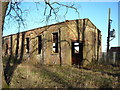 , and between it and me was a high redbrick wall
 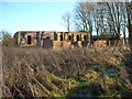 , with a space behind it which Grech identifies as the M/T (Motor Transport) Section parking bay, from the original stencilling on the wall Link
![]() although it is not next to the M/T shed as you might expect. Looking at the photos now, I can see that the wall had originally been three sides of a long covered shed, the roof of which has now gone.
although it is not next to the M/T shed as you might expect. Looking at the photos now, I can see that the wall had originally been three sides of a long covered shed, the roof of which has now gone.
Through the windows in the generator house, I could see a huge rusty metal girder, but I decided not to investigate it now, because I wanted to get as many photographs of the whole site before my presence was discovered. I peered round the corner of the generator house, and found myself on a tarmacked drive, obviously a continuation of the one starting at the main guardroom and running through the gate marked Private. It was covered with moss which was spongy underfoot.
Thinking it best to explore the buildings farthest away from the house first, I turned right on to this road, and started to walk up it. On my right was the temporary metal security fence, and on my left was a green space in which were several humps which reminded me of large recently-dug graves or small long barrows  . At the end of each hump was a concrete box or a construction made of laths covered with plastic. It turned out these were Stanton air raid shelters, Link
![]() each of them big enough for fifty men, the excrescences being either the entrances of the emergency escape hatches (I did not venture close enough to ascertain which).
each of them big enough for fifty men, the excrescences being either the entrances of the emergency escape hatches (I did not venture close enough to ascertain which).
Just beyond these on my left was the single-storey concrete-rendered brick block of flight offices 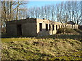 . These offices were ranged on either side of a long corridor
 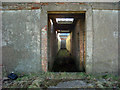 .
.
On my right, beyond the high metal fence, I could see two buildings in the rough field I had crossed earlier 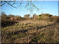 . One looked like a redbrick toilet block, but was in fact the small arms armoury. The other, half-covered in ivy, was the small arms firing range.
Continuing along the mossy drive, and just before the western boundary fence at the end, was what looked like a small swimming pool, but turned out to be the bases water storage tank 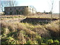 , capable of holding 200 gallons (900 litres) of water. This brought to mind a comment by one of the airmen stationed at the East Camp, who had said that the baths were marked with a line and must not be overfilled. Doubtless, with so many men stationed at the camps, water was at a premium, and of course extra was needed in case of fires caused by bombing.
Looking back to my left, I could see the main accommodation block, a two-story concrete-rendered brick building with metal window-frames 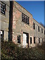 , built on an E-shaped plan, with the long side facing the afternoon sun.
Walking to the end of this, I peeped around the far corner, and saw some brick ancillary buildings 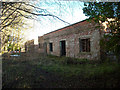 . Venturing further towards them, I saw on my left, at the end of the office block I had seen earlier, the stations squash court
 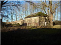 . The roof had originally been glazed to let in the light from above, and when John Grech photographed it in 2010 the interior was preserved in excellent condition. Link
![]()
Returning to the front of the accommodation block, I carried on until I came to the combined officers mess and office building. This was the architectural highlight of RAF Yatesbury West Camp. It was built in 1936 by the architect Cecil Jones from rendered brick with flat roofs and steel-framed windows. The complex was praised by Flight magazine in 1936 as a model school whose pattern few will equal and none better, and a 2003 report by English Heritage described the building as a crisp modern composition by Cecil Jones, the most significant of all the buildings erected for the 50 Civilian Service Flying Training Schools. Link![]() Link
Link![]()
A billiards room and a mess/ante-room for use by the instructors and officer pupils faced the garden front on the southwest side. Now, of course, it is in a sorry state 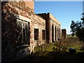 , although its former grandeur can be imagined from its façade
 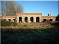 which faced the evening sun and is marked by a taller projecting block to the centre, which had french windows with fanlights above them set in four recessed semi-circular arches. Link
![]() Nowadays, there is a high unruly hedge blocking the view from those windows, but perhaps when the base was in use, you could sit there sipping your gin and watch the sun go down over the Cherhill monument. I couldnt help noticing that the soil was much softer near the hedge, and wondered whether there had once been an ornamental pond there.
Nowadays, there is a high unruly hedge blocking the view from those windows, but perhaps when the base was in use, you could sit there sipping your gin and watch the sun go down over the Cherhill monument. I couldnt help noticing that the soil was much softer near the hedge, and wondered whether there had once been an ornamental pond there.
Turning the corner at the end of the façade, the elevation facing south-east towards the airfield is only slightly less impressive 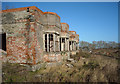 with its four projecting bay windows. This was the watch office and flying control: here were the offices for the chief flying instructor and time-keeper, and the pilots' changing-rooms. The aircraft control tower is on top of this building. Looking round the far corner of this building, I could see the kitchens at the back of the officers mess
 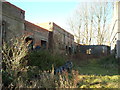 .
.
Walking parallel to the façade of the watch office in an easterly direction, I passed another block, this time the operations block 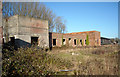 , which contained more administration offices and the training facilities. I was now walking on the concrete of the disused runway
 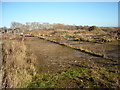 , which was overgrown with weeds and brambles, and scattered with debris abandoned by the builders when theyd left: bricks, pieces of wood, bits of plastic, and piles of spoil.
With the operations block on my left, I had a good view of the two hangars 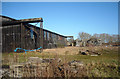 . The one nearest me had been restored
 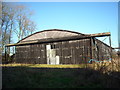 , but the other was in a state of almost complete collapse
 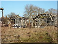 . I was now not far away from the white house, and I could hear sounds of banging coming from near there. At first I thought the white object in front of the furthest hangar was a car, and that the banging was coming from someone working in the hangar; but the car turned out to be a boat, beached miles from the nearest river, and the noise was being made by someone unseen near the house.
I got as close as I dared to photograph the ruined hangar, then backed off to look at the one that had been restored. It looked as if they had made a reasonable job of conserving it, because the hangar looked watertight, apart from some sheets of corrugated missing from the front; at least it was in no danger of collapsing. But it had not been restored to its original condition, as can be seen by comparison with a photograph taken in 2005 of the eastern hangar Link![]() which still appears to have one of its sliding doors partly intact.
which still appears to have one of its sliding doors partly intact.
With the hangars massive façade on my right, I cut back in toward the shelter of the trees. On the north wall of the restored hangar were the annexes 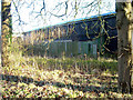 , still clad in corrugated metal, with their windows now covered with metal also. This was identical to the set-up with the eastern hangar
 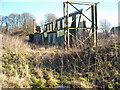 , see Link
![]() which shows how the eastern hangar in 2005.
which shows how the eastern hangar in 2005.
Off to my left, and quite close to the front of the restored hangar was the aircrew ready room, an evocative name and place if ever there was one 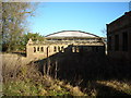
 . John Grechs collection of photos shows the inside of this building Link
![]() where the aircrews probably sat in two lines facing each other, cheerfully bantering to cover their nerves while they waited to be called.
where the aircrews probably sat in two lines facing each other, cheerfully bantering to cover their nerves while they waited to be called.
Beyond this and to my left were more reminders of the dangers of the place. Two dilapidated buildings to the east of the squash court on the other side of another mossy drive were for use by medics. That on my left, which still bears the faint remains of a red cross in a white oval on its gable, was the sick bay 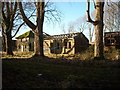 , while that on my right was another medical building
 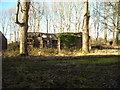 . Back along the drive to my right was the ambulance station
 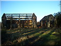 , and further along still, near the entrance, was the fire tender shed
 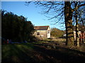 .
.
To the left of the ambulance station was the four-bayed M/T (Motor Transport) shed . I was now back on the original mossy drive I had set foot on before circumnavigating the site. Leaving the M/T shed on my right, I walked back to the generator house 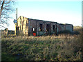 and went inside.
Above the door was a giant steel beam, to which a pulley was attached 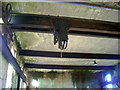 . The manufacturers name (Herbert Morris Ltd. of Loughborough) was printed on one side of the beam, plus the fact that the pulley was capable of lifting 4 tons (4.064 tonnes)
 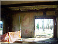 . This beam slid back and forth on metal wheels with cogs along another pair of beams on either side of the inside of the building: I had already seen one of these beams through the window. The pulley was used for lifting generators into and out of looked like three huge ceramic baths set into the floor on the right hand side of the building
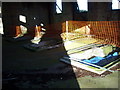
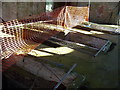 . (These generator mountings are best seen in John Grechs collection of photographs Link
![]() where they arent covered.) There was another similar, though slightly differently-shaped ceramic pit in the far left corner of the shed
where they arent covered.) There was another similar, though slightly differently-shaped ceramic pit in the far left corner of the shed 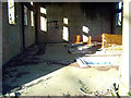 .
.
By this time, I thought I had hung around too long for my own good, and decided to scarper. I made my way back across the rough ground to the gap in the hedge near the pillbox. I still had a five mile walk planned, so I continued along Jugglers Lane.
Not much further along, the hedgerow on the left ended, and I had a good view back over the western end of the camp 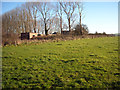 , and also over the edge of the escarpment on which it stands. Right over the other side of the field was a small building, but I wasnt going to plod all that way to see what it was. I photographed it, and later found out that it was another pillbox, this time a Type 27
  . Link
![]() Link
Link![]() Then I went on my way.
Then I went on my way.
When I got home, the first thing I did was look up my leaf and twig in Prime and Deacocks 'How to Identify Trees & Shrubs from Leaves or Twigs in Summer or Winter', a little booklet dating from 1942 that I picked up from a car boot sale. It wasnt much help, but the shape of the leaf was vaguely familiar. Then I realised that it was the same as the leaves of the tree at the end of the garden of the house where I grew up: a poplar. But I will still have to go back in the summer to prove it.
I also discovered the secrets of Hangar 45: have a look at Link![]() to see what the architects envisaged for the inside! Twenty-nine live/work units, communal work space, parking, a play space for children, and even a village shop, all under the hangars capacious saw-tooth roof. In case you are wondering what a live/work unit is, it is a place where people can work from home, thus reducing their carbon footprint by not commuting, and making use of otherwise awkward buildings such as warehouses and hangars. According to RIBA Journal February 2001 Link
to see what the architects envisaged for the inside! Twenty-nine live/work units, communal work space, parking, a play space for children, and even a village shop, all under the hangars capacious saw-tooth roof. In case you are wondering what a live/work unit is, it is a place where people can work from home, thus reducing their carbon footprint by not commuting, and making use of otherwise awkward buildings such as warehouses and hangars. According to RIBA Journal February 2001 Link![]() Hangar 45 would have housed 29 prefabricated timber live/work cassettes around a central street, with parking either side. In 2007, Wiltshire County Council Planning Committee discussed architect Mitchell Taylor Workshops proposals, raising some objections on the grounds that it was by no means a certainty that the proposed dwellings in this location will be utilised as such [i.e. for people to work from] or provide a totally sustainable community. Link
Hangar 45 would have housed 29 prefabricated timber live/work cassettes around a central street, with parking either side. In 2007, Wiltshire County Council Planning Committee discussed architect Mitchell Taylor Workshops proposals, raising some objections on the grounds that it was by no means a certainty that the proposed dwellings in this location will be utilised as such [i.e. for people to work from] or provide a totally sustainable community. Link![]() I dont know whether the proposal was ultimately passed, though it is clear from events elsewhere that the creation of live/work units was considered to be a slippery slope towards change of use from industrial to purely residential. In 2007, a number of people in Hackney were served with notices to quit their live/work spaces unless they immediately applied for planning permission for change of use. Link
I dont know whether the proposal was ultimately passed, though it is clear from events elsewhere that the creation of live/work units was considered to be a slippery slope towards change of use from industrial to purely residential. In 2007, a number of people in Hackney were served with notices to quit their live/work spaces unless they immediately applied for planning permission for change of use. Link![]() However, even with my penchant for trespassing, I havent the nerve to go snooping around Hangar 45 to discover the outcome.
However, even with my penchant for trespassing, I havent the nerve to go snooping around Hangar 45 to discover the outcome.
More photographs of RAF Yatesbury can be seen at Link![]() Link
Link![]() Link
Link![]() Link
Link![]() and Link
and Link![]() Also see Link
Also see Link![]()
And for a final treat, watch Link![]() or Link
or Link![]() in which the West Camp features as a set for the video of Doctorin the Tardis by the Timelords/KLF (1988). It gives a good view of the concrete runway and the two westernmost hangars, which were then almost intact, as well as being jolly good fun!
in which the West Camp features as a set for the video of Doctorin the Tardis by the Timelords/KLF (1988). It gives a good view of the concrete runway and the two westernmost hangars, which were then almost intact, as well as being jolly good fun!
- When
- Tue, 30 Dec 2014 at 17:59
- Grid Square
 SU0571
blog comments powered by Disqus