Beinn Eighe Reserve Mountain Trail
The Beinn Eighe Reserve provides two trails. A short woodland trail and a far longer mountain trail. The woodland trail is around 7 km and can take four hours because of the steep terrain.
According to others: The Mountain Trail is a fabulous trail to explore the hills of Beinn Eighe. This loop trail takes you up through ancient woodland, rugged grasslands and heath, to the beautiful heights of the mountain terraces. This is a memorable walk, with breathtaking views over the surrounding mountain landscape. The 6.5 km (4 mile) walk rises to 550 metres and takes three to four hours to complete. The path is steep and very rough in places, so it can be challenging for less experienced walkers. You will need to wear hillwalking boots and take food and warm waterproof clothing, as the weather can change quickly and the top of the trail is very exposed.
On a warm and sunny Spring Day with no need to hurry the walk took 4.5 hours and minor diversions were made. For an experienced walker/climber the steepness of the terrain was noticeable. The path has been excellently maintained since its creation in the 1990s. Its route does not coincide precisely with the OS 1:50,000 mapping but conforms to what is provided at 1:10,000.
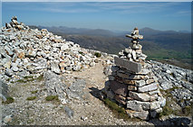
The path provides a grandstand view of Loch Maree with Slioch behind as well as views into the outliers of Beinn Eighe itself. Please note the path does not venture onto Beinn Eighe.
The two booklets will be useful for those visiting the Reserve.
Link![]() for the Mountain Trail
for the Mountain Trail
Link![]() for the Woodland Trail
for the Woodland Trail
The Mountain Trail joins the Woodland Trail for the last mile of the walk.
You can see this trip plotted on a map on the Geo-trips page Link .
- When
- Wed, 30 May 2018 at 11:26
- Grid Square
 NG9964
- Chosen Photo
blog comments powered by Disqus