J3475 : The Victoria Channel, Belfast
taken 43 years ago, near to Belfast, Co Antrim, Northern Ireland
This is 1 of 2 images, with title The Victoria Channel, Belfast in this square
The Victoria Channel, Belfast
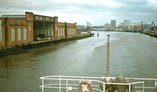
The Victoria Channel, seen from the ferry Ulster Queen departing for Liverpool. On the left is the Harland & Wolff steel store - subsequently demolished. In the background (just to the right of the flagpole) is Churchill House J3474 : Former Churchill House, Belfast also demolished. The smaller white building on the right is Tomb Street sorting office J3474 : Tomb Street sorting office, Belfast now re-clad.
Another point of interest (at the edge, upper right) is a scotch derrick crane on the Albert Quay also gone and replaced by the Stena terminal J3475 : Stena Line Terminal, Belfast (now disused upon a later move to the entrance to the harbour).
This view of the channel and the Lagan is now blocked by the cross-harbour road and railway bridges J3474 : Belfast Cross Harbour Links.
![Creative Commons Licence [Some Rights Reserved]](https://s1.geograph.org.uk/img/somerights20.gif)
|
· Find out How to reuse this image ·
Share:
|
|||||
| Start a discussion on J3475 | Suggest an update to this image | Contact the contributor | |||
Loading map... (JavaScript required)
- Grid Square
- J3475, 773 images (more nearby
 )
)
- Photographer
- Albert Bridge (find more nearby)
- Date Taken
- Thursday, 4 June, 1981 (more nearby)
- Submitted
- Friday, 30 January, 2009
- Place (from Tags)
- Category
- Harbour (more nearby)
- Subject Location
-
Irish:
 J 349 753 [100m precision]
WGS84: 54:36.5223N 5:54.7667W - Camera Location
-
Irish: J 349 754
- View Direction
- Southwest (about 225 degrees)
Other Tags
Image classification(about):
Geograph
This page has been viewed about 859 times.
View this location:
KML (Google Earth) ·
Google Maps ·
Bing Maps ·
Geograph Coverage Map ·
More Links for this image
·
Bing Maps ·
Geograph Coverage Map ·
More Links for this image