2009
SH7877 : Conwy Castle & Bridge across the rooftops
taken 15 years ago, near to Gyffin, Conwy, Wales
This is 1 of 147 images, with title starting with Conwy Castle in this square
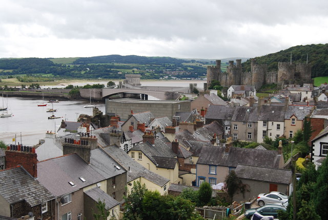
Conwy Castle & Bridge across the rooftops
Conwy castle is one of the most picturesque of Welsh castles and a masterpiece of medieval military architecture. The castle and town walls are now in the UNESCO World Heritage List as a site of outstanding universal value. They were built by Edward I between 1283 and 1289 and helped to complete the conquest of the Welsh princes in North Wales. In Conwy, the castle's commanding position on a rocky outcrop overlooking the estuary dictated its very size and shape and gave it its great military strength. Taken together the castle and the town walls of Conwy, planned as a single unit, are the most impressive of all the fortresses built by King Edward I. Over 1.2 km. long, the town walls defended the largest of Edward's Welsh frontier towns with their 21 towers and 3 gateways. The town walls also acted as the outermost defences of the castle, an imposing compact eight-towered stronghold surrounded by water on three sides. Nearest the town, the castle's own outer bailey housed the garrison, then, doubly defended by town wall and the outer bailey, came the king's private apartments in the castle's inner bailey. It is one of a ring of castles built by Edward I around Wales.
Grade I listed. Link
See other images of Conwy Castle and Town Walls
Grade I listed. Link
See other images of Conwy Castle and Town Walls
 Map © Crown Copyright")
TIP: Click the map for more Large scale mapping
- Grid Square
- SH7877, 2137 images (more nearby 🔍)
- Photographer
- N Chadwick (more nearby)
- Date Taken
- Sunday, 30 August, 2009 (more nearby)
- Submitted
- Friday, 11 September, 2009
- Subject Location
-
OSGB36:
 SH 784 775 [100m precision]
WGS84: 53:16.8295N 3:49.4986W - Camera Location
-
OSGB36: SH 780 777
- View Direction
- East-southeast (about 112 degrees)