V9282 : Lakes of the Killarney National Park
taken 31 years ago, 6 km SW of Muckross, Co Kerry, Ireland
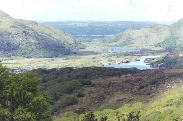
Lakes of the Killarney National Park
View down the valley onto the east end of Upper Lake. This and the river system below it form part of the Park, feeding down the valley through the narrow gap between two hills Glena and the Eagles Nest on the left and Torc Mountain on the right and through V9385 : The Meeting of the Waters into the largest lake, V9386 : Lough Leane by Killarney town. Part of Lough Leane and Muckross Lake can be seen here as a strip of water beyond the gap in the hills. Link
![Creative Commons Licence [Some Rights Reserved]](https://s1.geograph.org.uk/img/somerights20.gif)
|
· Find out How to reuse this image ·
Share:
|
|||||
| Start a discussion on V9282 | Suggest an update to this image | Contact the contributor | |||
Loading map... (JavaScript required)
- Grid Square
- V9282, 4 images (more nearby
 )
)
- Photographer
- D Gore (find more nearby)
- Date Taken
- 1993 (more nearby)
- Submitted
- Tuesday, 16 February, 2010
- Category
- Lake (more nearby)
- Subject Location
-
Irish:
 V 926 828 [100m precision]
WGS84: 51:59.2873N 9:33.7775W - Camera Location
-
Irish: V 923 824
- View Direction
- Northeast (about 45 degrees)
Image classification(about):
Geograph (Second Visitor for V9282)
· First in 5 Years (TPoint) (about)
This page has been viewed about 137 times.
View this location:
KML (Google Earth) ·
Google Maps ·
Bing Maps ·
Geograph Coverage Map ·
More Links for this image