J4893 : The Blackhead path, Whitehead (1)
taken 14 years ago, near to Whitehead, Co Antrim, Northern Ireland
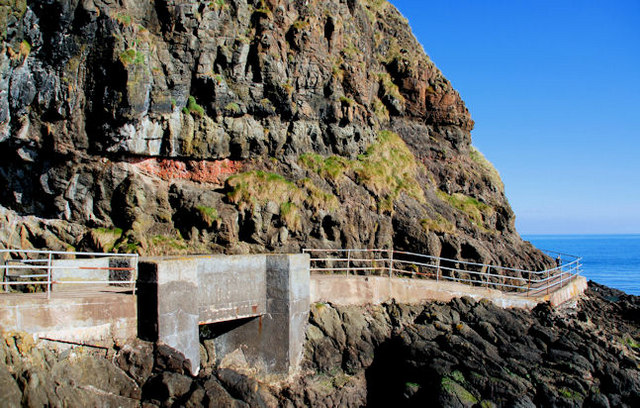
The Blackhead path, Whitehead (1)
The Blackhead path was designed by Berkley Deane Wise who also the engineer for the Gobbins path. This section, passing close to the caves, gives an idea of the principles used in building the latter. Continue to J4893 : The Blackhead path, Whitehead (2).
The Blackhead Path, Whitehead
A path running from The Banks at Whitehead, along the shore, to the Blackhead Lighthouse (with a parallel path running inland along the cliff and higher ground). It is possible to walk back to Whitehead from the lighthouse, on a surfaced path, via Muldersleigh Hill, McCreas Brae and the Islandmagee Road. Steep in places and not suitable for wheelchairs.
![Creative Commons Licence [Some Rights Reserved]](https://s1.geograph.org.uk/img/somerights20.gif)
|
· Find out How to reuse this image ·
Share:
|
|||||
| Start a discussion on J4893 | Suggest an update to this image | Contact the contributor | |||
Loading map... (JavaScript required)
- Grid Square
- J4893, 99 images (more nearby
 )
)
- Photographer
- Albert Bridge (find more nearby)
- Date Taken
- Tuesday, 9 March, 2010 (more nearby)
- Submitted
- Tuesday, 9 March, 2010
- Category
- Path > Path (more nearby)
- Subject Location
-
Irish:
 J 487 934 [100m precision]
WGS84: 54:45.9948N 5:41.4219W - Camera Location
-
Irish: J 486 933
- View Direction
- Northeast (about 45 degrees)
Image classification(about):
Geograph
This page has been viewed about 261 times.
View this location:
KML (Google Earth) ·
Google Maps ·
Bing Maps ·
Geograph Coverage Map ·
More Links for this image
·
Bing Maps ·
Geograph Coverage Map ·
More Links for this image