J4893 : The Blackhead lighthouse, Whitehead (3)
taken 14 years ago, near to Whitehead, Co Antrim, Northern Ireland
A path running from The Banks at Whitehead, along the shore, to the Blackhead Lighthouse (with a parallel path running inland along the cliff and higher ground). It is possible to walk back to Whitehead from the lighthouse, on a surfaced path, via Muldersleigh Hill, McCreas Brae and the Islandmagee Road. Steep in places and not suitable for wheelchairs.
The Bangor Boat made an extra trip to the Gobbins on Sunday 30 May 2010. The departure from Bangor was at 08.30 perfect to catch the early morning sun shining on the east-facing cliffs.
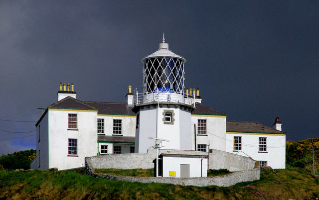
The octagonal lighthouse was designed by William Douglass, Engineer to the Commissioners of Irish Lights, and became operational in 1902. Originally painted red, this was changed to white in 1929. The lighthouse was converted to run on electricity on the 23rd September 1965; it now has a light visible for 27 nautical miles. Full time lightkeepers were withdrawn on 31st July 1975. The adjoining house was purchased by the Irish Landmark Trust and is now available to rent as self-catering accommodation.
![Creative Commons Licence [Some Rights Reserved]](https://s1.geograph.org.uk/img/somerights20.gif)
|
· Find out How to reuse this image ·
Share:
|
|||||
| Start a discussion on J4893 | Suggest an update to this image | Contact the contributor | |||
- Grid Square
- J4893, 99 images (more nearby
 )
)
- Photographer
- Albert Bridge (find more nearby)
- Date Taken
- Sunday, 30 May, 2010 (more nearby)
- Submitted
- Sunday, 30 May, 2010
- Category
- Lighthouse (more nearby)
- Subject Location
-
Irish:
 J 488 934 [100m precision]
WGS84: 54:46.0196N 5:41.3086W - Camera Location
-
Irish: J 489 934
- View Direction
- West-northwest (about 292 degrees)