J3474 : Corporation Square, Belfast
taken 14 years ago, near to Belfast, Co Antrim, Northern Ireland
This is 1 of 3 images, with title starting with Corporation Square in this square
Corporation Square, Belfast
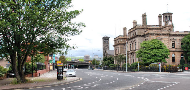
Corporation Square, from near the old Liverpool ferry terminal J3474 : The old Liverpool ferry terminal, Belfast, looking towards Corporation Street J3475 : Yellow line removal, Belfast. Tomb Street J3474 : Tomb Street, Belfast (3) is at the peach-coloured building on the middle left. Sinclair Seamens church J3474 : Sinclair Seamen's Presbyterian Church is at middle right and the Harbour Office J3474 : Belfast Harbour Commissioner's Office is on the right. The Artillery flats J3375 : Artillery flats, Belfast are in the background. Back in the 1960s a previous telephone box had operating instructions in English and French.
![Creative Commons Licence [Some Rights Reserved]](https://s1.geograph.org.uk/img/somerights20.gif)
|
· Find out How to reuse this image ·
Share:
|
|||||
|
There are 4 posts in a
discussion on J3474 (preview on the left) |
Suggest an update to this image | Contact the contributor | |||
Loading map... (JavaScript required)
- Grid Square
- J3474, 4349 images (more nearby
 )
)
- Photographer
- Albert Bridge (find more nearby)
- Date Taken
- Sunday, 1 August, 2010 (more nearby)
- Submitted
- Sunday, 1 August, 2010
- Category
- Street (more nearby)
- Subject Location
-
Irish:
 J 343 749 [100m precision]
WGS84: 54:36.3053N 5:55.3164W - Camera Location
-
Irish: J 344 749
- View Direction
- West-northwest (about 292 degrees)
Image classification(about):
Geograph
This page has been viewed about 134 times.
View this location:
KML (Google Earth) ·
Google Maps ·
Bing Maps ·
Geograph Coverage Map ·
More Links for this image
·
Bing Maps ·
Geograph Coverage Map ·
More Links for this image