J4187 : Somersault signals, Carrickfergus station
taken 40 years ago, near to Carrickfergus, Co Antrim, Northern Ireland
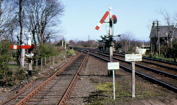
The line between Belfast York Road and Larne Harbour opened as far to Carrickfergus in 1848 and from Carrickfergus to Larne Harbour in 1862. There were stations at Belfast York Road (1848), Greencastle (1849/1916), Whitehouse (old station 1861/1906 replaced by a new station, further north 1906/1954), Whiteabbey (1848), Bleach Green 1934/1977), Jordanstown (by 1853), Trooperslane (by 1850), Mount (1925/72), Carrickfergus (old station 1848/62), Clipperstown (1925), Carrickfergus (1862), Barn (1925/77), Downshire (originally Downshire Park, 1925), Eden (1925/77), Kilroot (1862/77), Whitehead (first station 1863/64), Whitehead (second station 1864/77), Whitehead (1877), Whitehead Excursion (1907), Ballycarry (1862), Ballylig (now Magheramorne, 1862), Glynn (1864), Larne (1862/1974), Larne Town (new alignment, 1974) and Larne Harbour (1862).
York Road station closed in 1992, replaced by Yorkgate (on a different site) as part of the opening of the new cross-harbour line to Belfast Central.
The line between Belfast Central and Bleach Green Jct is also used by trains serving the Londonderry/Portrush lines.
Sources: Irish Railways Today (1967), the Northern Counties Railway (1973) and Johnsons Atlas & Gazetteer of the Railways of Ireland (1997).
![Creative Commons Licence [Some Rights Reserved]](https://s1.geograph.org.uk/img/somerights20.gif)
|
· Find out How to reuse this image ·
Share:
|
|||||
| Start a discussion on J4187 | Suggest an update to this image | Contact the contributor | |||
- Grid Square
- J4187, 669 images (more nearby
 )
)
- Photographer
- Albert Bridge (find more nearby)
- Date Taken
- Sunday, 22 April, 1984 (more nearby)
- Submitted
- Tuesday, 28 September, 2010
- Category
- Railway signals (more nearby)
- Subject Location
-
Irish:
 J 412 877 [100m precision]
WGS84: 54:43.0639N 5:48.4893W - Camera Location
-
Irish: J 412 877
- View Direction
- East-northeast (about 67 degrees)