J3471 : Rushfield Avenue, Belfast
taken 13 years ago, near to Belfast, Co Antrim, Northern Ireland
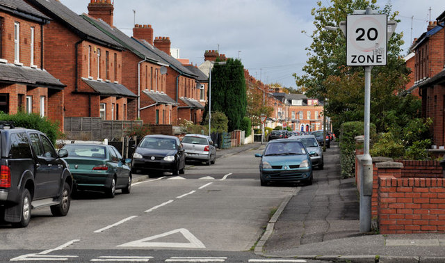
Rushfield Avenue, Belfast
A late 19th century street, running from Sunnyside Street (foreground), across Haywood Avenue, towards the Ormeau Road. The traffic calming measures (20mph speed limit and humps) are common in the immediate area. Not to be confused with Rushfield Terrace (Oldpark Road).
20 mph zones, Belfast
Photographs showing some of the places in Belfast where the maximum speed permitted is 20mph. The usual maximum, in most urban areas, is 30mph. The photographs submitted by me appear as a matter of neutral geographical and historical record only. I have no connection with any campaign or official body.
![Creative Commons Licence [Some Rights Reserved]](https://s1.geograph.org.uk/img/somerights20.gif)
|
· Find out How to reuse this image ·
Share:
|
|||||
| Start a discussion on J3471 | Suggest an update to this image | Contact the contributor | |||
Loading map... (JavaScript required)
- Grid Square
- J3471, 273 images (more nearby
 )
)
- Photographer
- Albert Bridge (find more nearby)
- Date Taken
- Saturday, 17 September, 2011 (more nearby)
- Submitted
- Saturday, 17 September, 2011
- Geographical Context
- Subject Location
-
Irish:
 J 345 717 [100m precision]
WGS84: 54:34.5521N 5:55.2479W - Camera Location
-
Irish: J 344 716
- View Direction
- North-northeast (about 22 degrees)
Other Tags
Image classification(about):
Geograph
This page has been viewed about 117 times.
View this location:
KML (Google Earth) ·
Google Maps ·
Bing Maps ·
Geograph Coverage Map ·
More Links for this image
·
Bing Maps ·
Geograph Coverage Map ·
More Links for this image