R9867 : Castles of Munster: Cullahill, Tipperary
taken 12 years ago, 4 km W of Borrisoleigh, Co Tipperary, Ireland
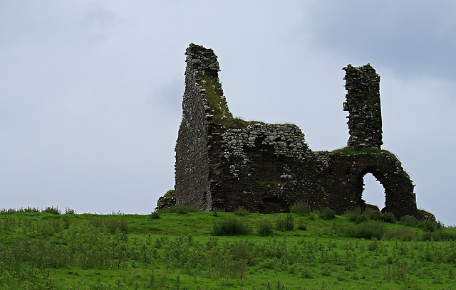
Castles of Munster: Cullahill, Tipperary
A fragmentary two storey C17 house clings to a rock outcrop in the Tipperary countryside. Both storeys have fireplaces and a chimneystack in the SW end wall, and there is a third fireplace in the upper storey with a projecting breast and high chimneystack on the NW side. Cullahill was held by Richard Burke in 1640.
![Creative Commons Licence [Some Rights Reserved]](https://s1.geograph.org.uk/img/somerights20.gif)
|
· Find out How to reuse this image ·
Share:
|
|||||
| Start a discussion on R9867 | Suggest an update to this image | Contact the contributor | |||
Loading map... (JavaScript required)
- Grid Square
- R9867 (more nearby
 )
)
- Photographer
- Mike Searle (find more nearby)
- Date Taken
- Wednesday, 20 June, 2012 (more nearby)
- Submitted
- Saturday, 14 July, 2012
- Geographical Context
- Subject Location
-
Irish:
 R 9890 6749 [10m precision]
WGS84: 52:45.5299N 8:1.0215W - Camera Location
-
Irish: R 9892 6739
- View Direction
- North-northwest (about 337 degrees)
Other Tags
This page has been viewed about 326 times.
View this location:
KML (Google Earth) ·
Google Maps ·
Bing Maps ·
Geograph Coverage Map ·
More Links for this image
·
Bing Maps ·
Geograph Coverage Map ·
More Links for this image