G6325 : Waterford Limerick & Western Railway
taken 12 years ago, 3 km from Coolaney, Co Sligo, Ireland
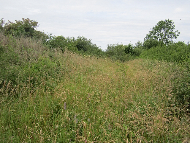
Covering some 139 miles in remote western Ireland, the first section of the Burma Road opened between Limerick and Ennis in 1859. It reached Athenry in 1869, where it joined the Athenry & Tuam Railway (opened 1860), extended to Claremorris in 1894 and Collooney Junction (with running powers to Sligo) in 1895. Coming under the control of the Waterford Limerick & Western Railway, the line was absorbed into the Great Southern & Western Railway in 1901 and became part of the Great Southern Railways in 1924, with ownership transferring to Cόras Iompair Éireann (CIÉ) in 1945. Known as the Burma Road due to the high number of level crossings, passenger services ceased between Collooney and Claremorris in 1963 and between Claremorris and Ennis in 1976, although passengers returned to Ennis Athenry on 29 March 2010. Freight services were withdrawn between Collooney Junction and Claremorris on 3 November 1975 and between Claremorris and Ennis on 11 November 2002. Although there is pressure to reopen the line between Athenry and Collooney, this quintessential Irish branch line will continue to slumber in the current economic climate.
![Creative Commons Licence [Some Rights Reserved]](https://s1.geograph.org.uk/img/somerights20.gif)
|
· Find out How to reuse this image ·
Share:
|
|||||
| Start a discussion on G6325 | Suggest an update to this image | Contact the contributor | |||
- Grid Square
- G6325, 2 images (more nearby
 )
)
- Photographer
- Richard Webb (find more nearby)
- Date Taken
- Saturday, 21 July, 2012 (more nearby)
- Submitted
- Wednesday, 1 August, 2012
- Geographical Context
- Railway (from Tags)
- Subject Location
-
Irish:
 G 637 258 [100m precision]
WGS84: 54:10.8178N 8:33.3279W - Camera Location
-
Irish: G 638 258
- View Direction
- WEST (about 270 degrees)