W6871 : Cork City railway 1975 - 5
taken 49 years ago, near to Cork, Co Cork, Ireland
The railway line from Cork to the port of Cobh was opened by the Cork & Youghal Railway between 1859 and 1862. Originally operating from a station at Summerhill directly above the Great Southern & Western railway station on Glanmire Road, Summerhill closed and services moved to the GS&WR station in 1893. Operated now by Iarnród Éireann (IÉ), this line is still open for passenger trains.
The railway from Cobh Junction (renamed Glounthaune in 1994) to Youghal opened to Midleton in 1859 and from Midleton to Youghal in 1860. This line closed to regular passenger traffic in 1963 and to all services on 2 June 1988. However, IÉ reopened the line from Glounthaune to Midleton in 2009, although there are currently no plans to revive the section from Midleton to Youghal.
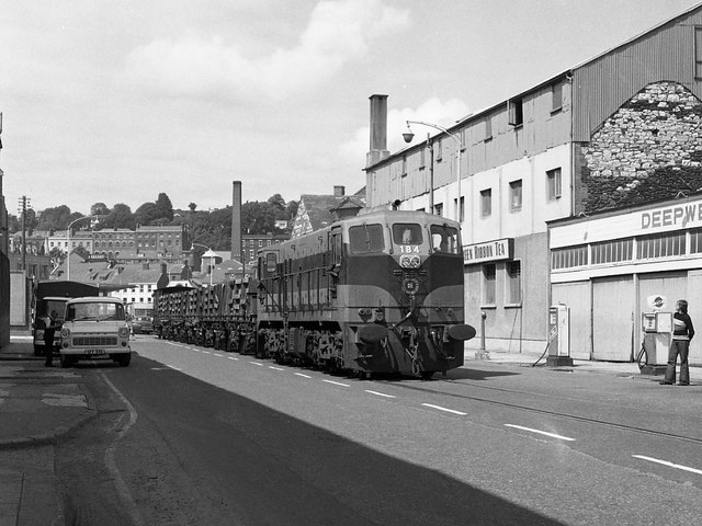
Linking the GS&WR station at Glanmire Road with the Cork Bandon & South Coast Railway at Albert Quay, the Cork City Railway opened in 1912. While the CB&SCR closed in 1961, the Albert Quay site was retained for freight traffic. Running in the middle of some main roads and crossing the River Lee twice, the Cork City line occasionally caused traffic chaos. It closed in 1976 following completion of new freight yards at North Esk on the Cork Cobh line and virtually no trace remains.
![Creative Commons Licence [Some Rights Reserved]](https://s1.geograph.org.uk/img/somerights20.gif)
|
· Find out How to reuse this image ·
Share:
|
|||||
| Start a discussion on W6871 | Suggest an update to this image | Contact the contributor | |||
- Grid Square
- W6871, 40 images (more nearby
 )
)
- Photographer
- The Carlisle Kid (find more nearby)
- Date Taken
- Friday, 18 July, 1975 (more nearby)
- Submitted
- Monday, 8 October, 2012
- Geographical Context
- Subject Location
-
Irish:
 W 680 718 [100m precision]
WGS84: 51:53.9065N 8:27.9274W - Camera Location
-
Irish: W 680 718
- View Direction
- North-northeast (about 22 degrees)