N8939 : Leaving Kilcock on N4, the main road to Dublin
taken 31 years ago, near to Kilcock, Co Kildare, Ireland
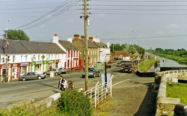
Leaving Kilcock on N4, the main road to Dublin
View eastward, towards Maynooth and Dublin. On the right is the Royal Canal, which runs from the River Shannon at Termonberry, near Longford (Co. Westmeath) all the way to Dublin, and here forms the boundary between Cos. Meath and Kildare. (Note the lock-gate beams on the right). (This was before the M4 motorway was built).
![Creative Commons Licence [Some Rights Reserved]](https://s1.geograph.org.uk/img/somerights20.gif)
|
· Find out How to reuse this image ·
Share:
|
|||||
| Start a discussion on N8939 | Suggest an update to this image | Contact the contributor | |||
Loading map... (JavaScript required)
- Grid Square
- N8939, 2 images (more nearby
 )
)
- Photographer
- Ben Brooksbank (find more nearby)
- Date Taken
- Monday, 14 June, 1993 (more nearby)
- Submitted
- Saturday, 20 October, 2012
- Geographical Context
- Subject Location
-
Irish:
 N 895 391 [100m precision]
WGS84: 53:23.6813N 6:39.2583W - Camera Location
-
Irish: N 895 391
- View Direction
- East-southeast (about 112 degrees)
Image classification(about):
Geograph (Second Visitor for N8939)
· First in 5 Years (TPoint) (about)
This page has been viewed about 156 times.
View this location:
KML (Google Earth) ·
Google Maps ·
Bing Maps ·
Geograph Coverage Map ·
More Links for this image
·
Bing Maps ·
Geograph Coverage Map ·
More Links for this image