J4972 : The loughshore, Newtownards (6)
taken 11 years ago, near to Newtownards, Co Down, Northern Ireland
This is 1 of 2 images, with title The loughshore, Newtownards (6) in this square
The loughshore, Newtownards (6)
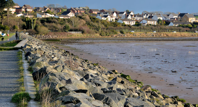
The northern end of the shore of Strangford Lough, about 30 minutes after low water Killyleagh, looking towards The Floodgates and the Portaferry Road. The seawall J4972 : The seawall, Newtownards runs along the left.
Sea defences, Newtownards
The town of Newtownards, on the shore of Strangford Lough, has, during its history, been subject to flooding. This is a collection of photographs showing some of the measures used to protect the town against flooding. Those photographs submitted by me appear as a matter of geographical and historical record only. I have no connection with any official body. They should not be interpreted as expressing any opinion about the adequacy of the defences.
![Creative Commons Licence [Some Rights Reserved]](https://s1.geograph.org.uk/img/somerights20.gif)
|
· Find out How to reuse this image ·
Share:
|
|||||
| Start a discussion on J4972 | Suggest an update to this image | Contact the contributor | |||
Loading map... (JavaScript required)
- Grid Square
- J4972, 81 images (more nearby
 )
)
- Photographer
- Albert Bridge (find more nearby)
- Date Taken
- Wednesday, 5 December, 2012 (more nearby)
- Submitted
- Wednesday, 5 December, 2012
- Geographical Context
- Subject Location
-
Irish:
 J 499 729 [100m precision]
WGS84: 54:34.9484N 5:40.8690W - Camera Location
-
Irish: J 497 729
- View Direction
- EAST (about 90 degrees)
Other Tags
Image classification(about):
Geograph
This page has been viewed about 93 times.
View this location:
KML (Google Earth) ·
Google Maps ·
Bing Maps ·
Geograph Coverage Map ·
More Links for this image
·
Bing Maps ·
Geograph Coverage Map ·
More Links for this image