J4273 : Dundonald railway station (site of) (1)
taken 10 years ago, near to Dundonald, Co Down, Northern Ireland
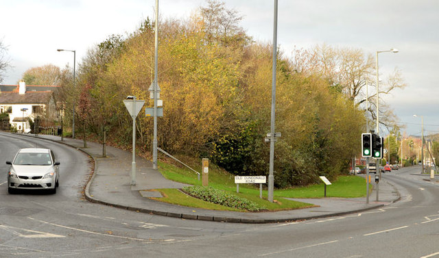
Dundonald railway station (site of) (1)
Dundonald station was on an embankment at the apex of the Old Dundonald Road (left) and the Comber Road. The station has gone but the trackbed is now part of the Comber Greenway J4273 : The Comber Greenway, Dundonald marked by the conspicuous clump of trees. This view is towards Knock station J3873 : Former Knock station, Belfast (2008-1) and Queens Quay J3474 : Queen's Quay railway station. The Comber Road (foreground) was crossed by an underbridge. J4273 : Dundonald railway station (site of) (2) shows a similar view from the Greenway.
The Belfast and County Down Railway
The Belfast and County Down Railway ran from Queens Quay station in Belfast to Castlewellan via Comber, Downpatrick and Newcastle. There were also lines from Comber to Donaghadee via Newtownards, Belfast to Bangor and branches from Ballynahinch Jct to Ballynahinch and Downpatrick to Ardglass. The lines opened between 1848 and 1892. All closed by 1950 except for Castlewellan Newcastle which survived until 1955 as part of the GNR(I) route from Belfast via Banbridge and the Bangor line which remains open but from Belfast Central.
![Creative Commons Licence [Some Rights Reserved]](https://s1.geograph.org.uk/img/somerights20.gif)
|
· Find out How to reuse this image ·
Share:
|
|||||
| Start a discussion on J4273 | Suggest an update to this image | Contact the contributor | |||
Loading map... (JavaScript required)
- Grid Square
- J4273, 49 images (more nearby
 )
)
- Photographer
- Albert Bridge (find more nearby)
- Date Taken
- Monday, 9 December, 2013 (more nearby)
- Submitted
- Monday, 9 December, 2013
- Geographical Context
- Place (from Tags)
- Subject Location
-
Irish:
 J 422 731 [100m precision]
WGS84: 54:35.1676N 5:47.9856W - Camera Location
-
Irish: J 423 730
- View Direction
- Northwest (about 315 degrees)
Other Tags
Image classification(about):
Geograph
This page has been viewed about 313 times.
View this location:
KML (Google Earth) ·
Google Maps ·
Bing Maps ·
Geograph Coverage Map ·
More Links for this image
·
Bing Maps ·
Geograph Coverage Map ·
More Links for this image