J3986 : Larne Rural District Council fire hydrant post, Trooperslane, Carrickfergus
taken 10 years ago, near to Greenisland, Co Antrim, Northern Ireland
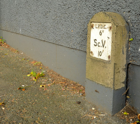
Larne Rural District Council fire hydrant post, Trooperslane, Carrickfergus
A post marking a section control valve, on the Trooperslane Road, near the Old Shore Road a survivor from before the reorganisation of local government in 1973. The initials LRDC mean Larne Rural District Council which administered a wider area than just the immediate environs of Larne town. See also J3193 : Larne Rural District Council fire hydrant post, Ballynure (March 2016).
![Creative Commons Licence [Some Rights Reserved]](https://s1.geograph.org.uk/img/somerights20.gif)
|
· Find out How to reuse this image ·
Share:
|
|||||
| Start a discussion on J3986 | Suggest an update to this image | Contact the contributor | |||
Loading map... (JavaScript required)
- Grid Square
- J3986, 25 images (more nearby
 )
)
- Photographer
- Albert Bridge (find more nearby)
- Date Taken
- Tuesday, 22 April, 2014 (more nearby)
- Submitted
- Tuesday, 22 April, 2014
- Geographical Context
- Place (from Tags)
- Subject Location
-
Irish:
 J 391 863 [100m precision]
WGS84: 54:42.3621N 5:50.5381W - Camera Location
-
Irish: J 391 863
- View Direction
- NORTH (about 0 degrees)
Other Tags
Image classification(about):
Supplemental image
This page has been viewed about 102 times.
View this location:
KML (Google Earth) ·
Google Maps ·
Bing Maps ·
Geograph Coverage Map ·
More Links for this image
·
Bing Maps ·
Geograph Coverage Map ·
More Links for this image