TQ1851 : The old road across Zig Zag Road
taken 19 years ago, near to Westhumble, Surrey, England
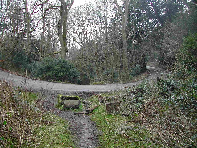
Despite appearances, this photograph is not taken with a fish-eye lens: Zig Zag Road here performs a tight hairpin bend to cross the coombe.
Boxhill Road is now known as the public road between Headley Common Road near Pebble Coombe and Box Hill Village, the continuation of which, via Zig Zag Road past Box Hill viewpoint and down to Mickleham near Burford Bridge, is a private road owned by the National Trust. However, Boxhill Road continues along two separate limbs, towards Mickleham and to Boxhill Bridge. Both limbs remain public roads, but neither is tarred, and one is currently impassable in part.
The northern limb lies to the north of Box Hill viewpoint, but is currently obstructed by vegetation over a short stretch, and by a large tree trunk. It crosses Zig Zag Road at the highest of the three hairpin bends (this one a little below the visitor centre), and (now freely passable) continues down the coombe to rejoin Zig Zag Road at the lowest of the three hairpin bends (the last part of Zig Zag Road, from the lowest hairpin bend to the junction with Old London Road, is therefore a public road). It seems likely that the old road went out of regular use by carriages in the late nineteenth century after Zig Zag Road had been thrown open to public use by the estate, for the private road offered a better surface and a gentler gradient for horse drawn traffic.
The other limb of Boxhill Road descended from the western end of the village, through what is now the car park of the Smith & Western restaurant, round the back of Boxhurst, to become established as a tarred road below Boxhurst down to Boxhill Bridge, and over the River Mole to join what is now the Old Coach Road across Betchworth Park to Buckland (the present junction with Reigate Road east to Reigate was constructed in the late 1920s).
Zig Zag Road is a private road, owned by the National Trust, which ascends from near Burford Bridge to the summit of Box Hill. Although private, no toll is charged by the Trust, although parking fees are sought at the summit car parks. The trust retains the right to close the road occasionally, to avoid a public right of way being acquired.
The first stretch of Zig Zag Road, from the junction with Old London Road to the first hairpin bend is actually public road: the private section begins only on the corner. This is because the public road still continues up the bottom of the valley, now unsurfaced, eventually crossing Zig Zag Road at the third hairpin bend a little below the visitors' centre, before continuing across the woodland north of the recreational area, to rejoin Zig Zag Road just west of the village. Some of the route above the third hairpin bend is now obstructed and overgrown, but it remains a public road.
 Map © Crown Copyright")
- Grid Square
- TQ1851, 54 images (more nearby 🔍)
- Photographer
- Hugh Craddock (more nearby)
- Date Taken
- Tuesday, 8 February, 2005 (more nearby)
- Submitted
- Monday, 25 August, 2014
- Subject Location
-
OSGB36:
 TQ 1805 5149 [10m precision]
WGS84: 51:15.0223N 0:18.5945W - Camera Location
-
OSGB36: TQ 1806 5147
- View Direction
- Northwest (about 315 degrees)