J3067 : The River Lagan in flood, Drumbeg, Dunmurry - November 2014(5)
taken 9 years ago, near to Drumbeg, Co Down, Northern Ireland
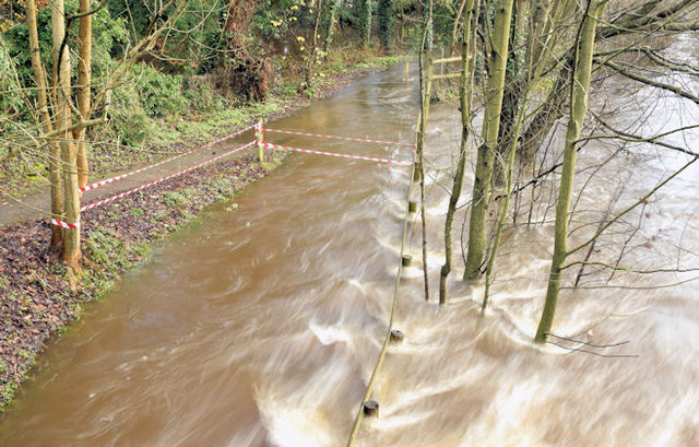
The River Lagan in flood, Drumbeg, Dunmurry - November 2014(5)
The River Lagan (having burst its banks) in full flow immediately downstream of the Drum Bridge J3067 : The Drum Bridge, Drumbeg. J3067 : Flooded towpath, Drumbeg, Dunmurry - November 2014(1) is on the left. J3067 : The River Lagan from the Drum Bridge (1) (March 2010) shows a much lower level.
The River Lagan in flood 14/15 November 2014
Prolonged rain, during November 2014 (especially on 13 November), caused many rivers and drains to overflow, leading to extensive flooding in many parts of Northern Ireland but particularly Cos Armagh and Down. In Belfast the River Lagan (which has its source in the middle of Co Down J3145 : The source of the River Lagan) had broken its banks in several places. This is a collection of photographs taken between Ballyskeagh and Newforge on 14/15 November 2014. I have included, where possible. links to photographs showing, for comparison, the area without flooding.
The River Lagan at the Drum Bridge
Photographs showing the changing seasons, on the River Lagan, at the Drum Bridge on the Upper Malone Road.
![Creative Commons Licence [Some Rights Reserved]](https://s1.geograph.org.uk/img/somerights20.gif)
|
· Find out How to reuse this image ·
Share:
|
|||||
| Start a discussion on J3067 | Suggest an update to this image | Contact the contributor | |||
Loading map... (JavaScript required)
- Grid Square
- J3067, 257 images (more nearby
 )
)
- Photographer
- Albert Bridge (find more nearby)
- Date Taken
- Saturday, 15 November, 2014 (more nearby)
- Submitted
- Saturday, 15 November, 2014
- Geographical Context
- Place (from Tags)
- Subject Location
-
Irish:
 J 306 671 [100m precision]
WGS84: 54:32.1458N 5:58.9581W - Camera Location
-
Irish: J 306 671
- View Direction
- EAST (about 90 degrees)
Other Tags
Image classification(about):
Geograph
This page has been viewed about 174 times.
View this location:
KML (Google Earth) ·
Google Maps ·
Bing Maps ·
Geograph Coverage Map ·
More Links for this image
·
Bing Maps ·
Geograph Coverage Map ·
More Links for this image