J6086 : Mew Island lighthouse near Donaghadee (July 2015)
taken 9 years ago, 6 km N of Donaghadee, Co Down, Northern Ireland
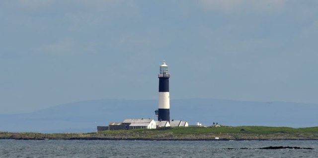
Mew Island lighthouse near Donaghadee (July 2015)
Its becoming increasingly unlikely that Ill ever land on Mew Island so I have to settle for this shot from beside the Bangor-Donaghadee road. The Galloway coast (appx 15 miles) is in the background.
Mew Island lighthouse, Copeland Islands near Donaghadee
The present lighthouse and fog signal on Mew Island was established on 1st November 1884 when its predecessor, on Lighthouse Island, was discontinued. It was converted to automatic operation with the lighthouse keepers permanently withdrawn on 29th March 1996. The station is in the care of an attendant. The aids to navigation are also monitored via a telemetry link from Irish Lights Dun Laoghaire.
A detailed description in available on the Irish Lights website Link
![Creative Commons Licence [Some Rights Reserved]](https://s1.geograph.org.uk/img/somerights20.gif)
|
· Find out How to reuse this image ·
Share:
|
|||||
| Start a discussion on J6086 | Suggest an update to this image | Contact the contributor | |||
Loading map... (JavaScript required)
- Grid Square
- J6086, 29 images (more nearby
 )
)
- Photographer
- Albert Bridge (find more nearby)
- Date Taken
- Saturday, 18 July, 2015 (more nearby)
- Submitted
- Saturday, 18 July, 2015
- Geographical Context
- Place (from Tags)
- Subject Location
-
Irish:
 J 603 862 [100m precision]
WGS84: 54:41.8977N 5:30.8104W - Camera Location
-
Irish: J 572 819
- View Direction
- Northeast (about 45 degrees)
Other Tags
Image classification(about):
Supplemental image
This page has been viewed about 80 times.
View this location:
KML (Google Earth) ·
Google Maps ·
Bing Maps ·
Geograph Coverage Map ·
More Links for this image
·
Bing Maps ·
Geograph Coverage Map ·
More Links for this image