2016
SU3938 : WWII Hampshire - RAF Chilbolton Battle HQ (1)
taken 8 years ago, near to Chilbolton, Hampshire, England
WWII Hampshire - RAF Chilbolton Battle HQ (1)
-
Airfield Battle Headquarters: DoB ID: e28387
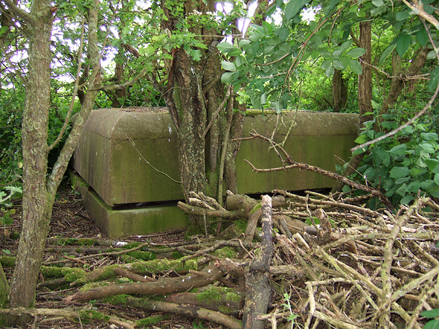
The familiar square cupola of an airfield Battle Headquarters dating from the earliest part of the Second World War lies hidden in dense undergrowth in a field alongside the footpath. Most RAF airfields built these as control centres in the event the airfield was overrun by enemy forces. This was the Battle HQ of the former wartime airfield of RAF Chilbolton, and is a standard type having a single cupola with viewing slits set just above ground level.
RAF Chilbolton airfield was opened in Sept 1940 as a satellite of RAF Middle Wallop, and was in use as a relief landing ground. It very soon was pressed into service during the latter stages of the Battle of Britain when it hosted its own Hawker Hurricane squadrons flying Mk1's. Later in the war the airfield was substantially upgraded with concrete runways, a perimeter track, and dispersal pens when various USAAF squadrons were based here. The airfield was handed back to the RAF in 1945, and was the first RAF station to fly the new De Havilland Vampire jet aircraft. The station closed in 1946.
SU3938 : WWII Hampshire - RAF Chilbolton Battle HQ (2)
Airfield Battle Headquarters: DoB ID: e28387
The familiar square cupola of an airfield Battle Headquarters dating from the earliest part of the Second World War lies hidden in dense undergrowth in a field alongside the footpath. Most RAF airfields built these as control centres in the event the airfield was overrun by enemy forces. This was the Battle HQ of the former wartime airfield of RAF Chilbolton, and is a standard type having a single cupola with viewing slits set just above ground level.
RAF Chilbolton airfield was opened in Sept 1940 as a satellite of RAF Middle Wallop, and was in use as a relief landing ground. It very soon was pressed into service during the latter stages of the Battle of Britain when it hosted its own Hawker Hurricane squadrons flying Mk1's. Later in the war the airfield was substantially upgraded with concrete runways, a perimeter track, and dispersal pens when various USAAF squadrons were based here. The airfield was handed back to the RAF in 1945, and was the first RAF station to fly the new De Havilland Vampire jet aircraft. The station closed in 1946.
SU3938 : WWII Hampshire - RAF Chilbolton Battle HQ (2)
 Map © Crown Copyright")
TIP: Click the map for more Large scale mapping
- Grid Square
- SU3938, 33 images (more nearby 🔍)
- Photographer
- Mike Searle (more nearby)
- Date Taken
- Thursday, 2 June, 2016 (more nearby)
- Submitted
- Thursday, 2 June, 2016
- Subject Location
-
OSGB36:
 SU 3908 3884 [10m precision]
WGS84: 51:8.8497N 1:26.5611W - Camera Location
-
OSGB36: SU 3907 3885
- View Direction
- South-southeast (about 157 degrees)