V3763 : Bolus Head
taken 17 years ago, 6 km SSW of Keel, Co Kerry, Ireland
Bolus Head
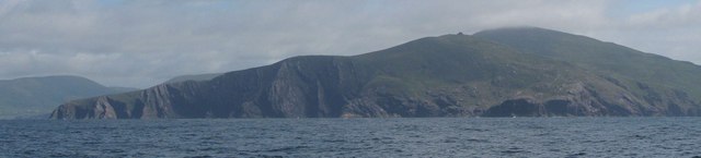
Bolus Head covers several grid squares. V3763 contains the NW point and the rest of the Head stretches away to the SW dominating V3862. In the photo, the NW point is to the left backed by the distant hills. A ruin tops the hill behind the bay. The southern point is below the cloudy peak.
![Creative Commons Licence [Some Rights Reserved]](https://s1.geograph.org.uk/img/somerights20.gif)
|
· Find out How to reuse this image ·
Share:
|
|||||
| Start a discussion on V3763 | Suggest an update to this image | Contact the contributor | |||
Loading map... (JavaScript required)
- Grid Square
- V3763 (more nearby
 )
)
- Photographer
- Robert Wilcox (find more nearby)
- Date Taken
- Tuesday, 10 July, 2007 (more nearby)
- Submitted
- Thursday, 26 July, 2007
- Category
- Headland (coastal feature) (more nearby)
- Subject Location
-
Irish:
 V 37 63 [1000m precision]
WGS84: 51:48.0426N 10:21.3879W - Camera Location
-
Irish: V 36 58
- View Direction
- Northeast (about 45 degrees)
Image classification(about):
Supplemental image
This page has been viewed about 521 times.
View this location:
KML (Google Earth) ·
Google Maps ·
Bing Maps ·
Geograph Coverage Map ·
More Links for this image
·
Bing Maps ·
Geograph Coverage Map ·
More Links for this image