1997
SS1348 : North lighthouse - Lundy Island
taken 27 years ago, 4 km NNW of Lundy, Devon, England
North lighthouse - Lundy Island
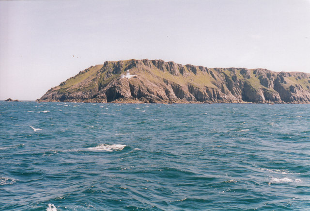
A view of the north lighthouse on its rocky perch at the northern end of Lundy Island. A very necessary addition to the scene this lighthouse, along with its partner at the southern end of the island, was opened in 1897 and automated in 1985. The pair replaced the Old Light which stood at a high point on the island, was shrouded in fog rendering it useless to crews at their time of need. This view was taken from the PS (paddle steamer) Waverley on a day cruise from Ilfracombe but the sea conditions on that day meant that we were unable to land and had to be content with a circuit of the island. But in the September of that year I was there for a holiday and I must go back again for more of that Lundy morning feeling. I stayed in Old Light Cottage, booked with the Landmark Trust, where the previous occupant that day was landscape photographer Derry Brabbs, but I missed him by only a few hours. Time taken not available.
 Map © Crown Copyright")
TIP: Click the map for more Large scale mapping
- Grid Square
- SS1348, 39 images (more nearby 🔍)
- Photographer
- Martin Richard Phelan (more nearby)
- Date Taken
- May 1997 (more nearby)
- Submitted
- Monday, 30 January, 2017
- Subject Location
-
OSGB36:
 SS 1306 4813 [10m precision]
WGS84: 51:12.1030N 4:40.6348W - Camera Location
-
OSGB36: SS 1291 4825
- View Direction
- Southeast (about 135 degrees)