2017
SU7103 : WWII Hampshire: Hayling Island - Havant Road pillbox (3)
taken 7 years ago, near to North Hayling, Hampshire, England
WWII Hampshire: Hayling Island - Havant Road pillbox (3)
-
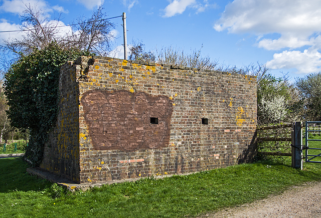
Pillbox (unclassified): DoB ID: S0008615
This pillbox is a familiar sight along the main road onto the island, and once would have stood adjacent to a heavy anti-aircraft gun battery in the field nearby. There are two embrasures visible on the south facing side. The entrance is behind, hidden in vegetation.
SU7203 : WWII Hampshire: Hayling Island - Northney Heavy Anti-Aircraft Battery (4)
 Map © Crown Copyright")
TIP: Click the map for more Large scale mapping
- Grid Square
- SU7103, 71 images (more nearby 🔍)
- Photographer
- Mike Searle (more nearby)
- Date Taken
- Tuesday, 21 March, 2017 (more nearby)
- Submitted
- Thursday, 23 March, 2017
- Subject Location
-
OSGB36:
 SU 7195 0375 [10m precision]
WGS84: 50:49.7295N 0:58.7861W - Camera Location
-
OSGB36: SU 7194 0374
- View Direction
- Northeast (about 45 degrees)