2017
SZ7099 : WWII Hampshire: Hayling Island - Sinah Heavy Anti-Aircraft Battery (34)
taken 7 years ago, near to South Hayling, Hampshire, England
WWII Hampshire: Hayling Island - Sinah Heavy Anti-Aircraft Battery (34)
-
Heavy Anti-Aircraft Battery: DoB ID: e00047
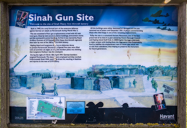
This interpretation panel of the wartime HAA site at Sinah has been provided by Havant Borough Council. The HAA Battery site is now scheduled by Historic England as an Ancient Monument, one of the best preserved of its kind. Tragically, it was the scene of a disaster on the night of 17th & 18th April 1941, when successful decoys set up to lure enemy bomber formations away from the City of Portsmouth resulted in a direct hit on the Sinah gun site killing six men of 219 Battery, 57th HAA Regiment, Royal Artillery. They are commemorated on a wall plaque in one of the emplacements. Those who died were: James Bardoe, James Collingbine, Arthur Farmer, Reginald Knight, James Powell, and Leonard Ward. Link
A layout diagram of the site can be seen by clicking on the largest image size of "More sizes" and zooming in as required.
Google Earth: Link
SZ7099 : WWII Hampshire: Hayling Island - Sinah Heavy Anti-Aircraft Battery (35)
Heavy Anti-Aircraft Battery: DoB ID: e00047
This interpretation panel of the wartime HAA site at Sinah has been provided by Havant Borough Council. The HAA Battery site is now scheduled by Historic England as an Ancient Monument, one of the best preserved of its kind. Tragically, it was the scene of a disaster on the night of 17th & 18th April 1941, when successful decoys set up to lure enemy bomber formations away from the City of Portsmouth resulted in a direct hit on the Sinah gun site killing six men of 219 Battery, 57th HAA Regiment, Royal Artillery. They are commemorated on a wall plaque in one of the emplacements. Those who died were: James Bardoe, James Collingbine, Arthur Farmer, Reginald Knight, James Powell, and Leonard Ward. Link
A layout diagram of the site can be seen by clicking on the largest image size of "More sizes" and zooming in as required.
Google Earth: Link
SZ7099 : WWII Hampshire: Hayling Island - Sinah Heavy Anti-Aircraft Battery (35)
 Map © Crown Copyright")
TIP: Click the map for more Large scale mapping
- Grid Square
- SZ7099, 140 images (more nearby 🔍)
- Photographer
- Mike Searle (more nearby)
- Date Taken
- Saturday, 25 March, 2017 (more nearby)
- Submitted
- Tuesday, 28 March, 2017
- Subject Location
-
OSGB36:
 SZ 700 994 [100m precision]
WGS84: 50:47.4075N 1:0.4540W - Camera Location
-
OSGB36: SZ 700 994
- View Direction
- East-southeast (about 112 degrees)