J3674 : Nos 5-11 Holywood Road, Belfast (April 2017)
taken 7 years ago, 3 km from Belfast, Co Antrim, Northern Ireland
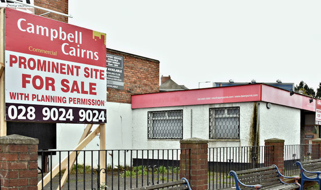
Nos 5-11 Holywood Road, Belfast (April 2017)
Now with a for sale sign. The agents description includes The subject site is probably one of the most prominent sites in East Belfast, situated at the junction where the Holywood Road meets with the Upper Newtownards Road and the Newtownards Road, known as Holywood Arches . . . . . The planning permission granted states: Ref No: Z/2013/1251/F 'Erection of 3 storey building with two ground floor retail units and two upper floors of office accomodation [sic] and external bin store area.'
Nos 5-11 Holywood Road, Belfast
A site, at the corner of the Holywood Road and the Upper Newtownards Road, for which there is the following planning permission (15 January 2015): 29/10/2013 . . . Z/2013/1251/F 5-11 Holywood Road Holywood Arches Belfast Erection of 3 storey building with ground floor retail space and two upper floors of office accommodation and external bin store area. The photographs submitted by me appear as a matter of geographical and historical record only. I have no connection with any of the parties involved in the proposed development.
![Creative Commons Licence [Some Rights Reserved]](https://s1.geograph.org.uk/img/somerights20.gif)
|
· Find out How to reuse this image ·
Share:
|
|||||
| Start a discussion on J3674 | Suggest an update to this image | Contact the contributor | |||
Loading map... (JavaScript required)
- Grid Square
- J3674, 822 images (more nearby
 )
)
- Photographer
- Albert Bridge (find more nearby)
- Date Taken
- Saturday, 8 April, 2017 (more nearby)
- Submitted
- Saturday, 8 April, 2017
- Geographical Context
- Place (from Tags)
- Primary Subject of Photo
- Subject Location
-
Irish:
 J 365 742 [100m precision]
WGS84: 54:35.8603N 5:53.2778W - Camera Location
-
Irish: J 365 742
- View Direction
- East-southeast (about 112 degrees)
Other Tags
This page has been viewed about 120 times.
View this location:
KML (Google Earth) ·
Google Maps ·
Bing Maps ·
Geograph Coverage Map ·
More Links for this image
·
Bing Maps ·
Geograph Coverage Map ·
More Links for this image