2017
SU7315 : Paths on Chalton Downs
taken 7 years ago, near to Chalton, Hampshire, England
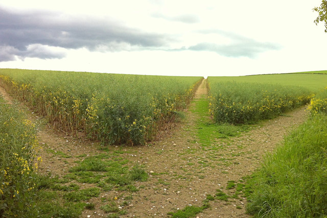
Paths on Chalton Downs
Three public footpaths beckon over Chalton Downs: the right (Clanfield 052/14/2) being the Staunton Way and Sussex Border Path onto Idsworth Down, the middle (Clanfield 052/15/1) dropping down through the grassy lower slopes of the downs towards Heberdens, and the left (Clanfield 052/16/1) towards Huckswood Lane and Compton. The junction of the paths is immediately opposite the crossing of the farm road from Manor Farm, whereas the definitive map shows the junction about 100m into the field.
Sussex Border Path
The Sussex Border Path is a footpath route nearly 150 miles long around the inland boundary of the county of Sussex. The county owes its origins to the kingdom of the South Saxons and can claim to have one of the longest inland county boundaries from Emsworth to Rye. The route was devised in 1983 and is well signed along most of the route. Website Link

Map: Link
Staunton Way
The Staunton Way is a 21 mile route from Queen Elizabeth Country Park, near Petersfield on the South Downs to Staunton Country Park near Havant. It is named after Sir George Staunton, an early 19th century Portsmouth MP who created a country estate, which now forms the Staunton Country Park. The footpath roughly follows the Hampshire / Sussex Border.
Wikipedia: Link
Link
 Map © Crown Copyright")
TIP: Click the map for more Large scale mapping
- Grid Square
- SU7315, 161 images (more nearby 🔍)
- Photographer
- Hugh Craddock (more nearby)
- Date Taken
- Friday, 19 May, 2017 (more nearby)
- Submitted
- Sunday, 21 May, 2017
- Subject Location
-
OSGB36:
 SU 7343 1566 [10m precision]
WGS84: 50:56.1433N 0:57.3822W - Camera Location
-
OSGB36: SU 7336 1580
- View Direction
- South-southeast (about 157 degrees)