J6086 : The 'Aeolus' off Mew Island
taken 7 years ago, 7 km NNE of Donaghadee, Co Down, Northern Ireland
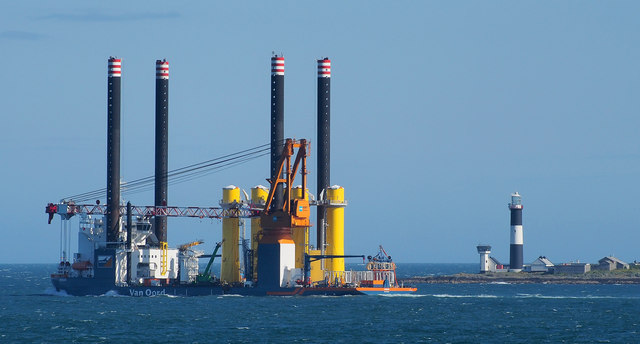
The 'Aeolus' off Mew Island
The jack-up construction vessel 'Aeolus' Link passing Mew Island Lighthouse J6086 : Mew Island Lighthouse and heading for Walney Wind Farm Link in the Irish Sea with more turbine components.
Wind turbine parts, Belfast harbour
This collection shows some of the parts and the vessels used to transport them at sea.
![Creative Commons Licence [Some Rights Reserved]](https://s1.geograph.org.uk/img/somerights20.gif)
|
· Find out How to reuse this image ·
Share:
|
|||||
| Start a discussion on J6086 | Suggest an update to this image | Contact the contributor | |||
Loading map... (JavaScript required)
- Grid Square
- J6086, 29 images (more nearby
 )
)
- Photographer
- Rossographer (find more nearby)
- Date Taken
- Wednesday, 9 August, 2017 (more nearby)
- Submitted
- Monday, 14 August, 2017
- Geographical Context
- Primary Subject of Photo
- Subject Location
-
Irish:
 J 607 867 [100m precision]
WGS84: 54:42.1810N 5:30.4300W - View Direction
- South-southeast (about 157 degrees)
Other Tags
This page has been viewed about 69 times.
View this location:
KML (Google Earth) ·
Google Maps ·
Bing Maps ·
Geograph Coverage Map ·
More Links for this image