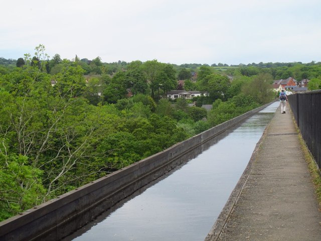
SJ2741 : Close your eyes now if you suffer from vertigo
taken 7 years ago, near to Froncysyllte, Wrexham/Wrecsam, Wales
The Llangollen canal is an arm of the Shropshire Union canal that runs from Hurleston Junction to Llangollen with a wide variety of scenery along its course. Its total length is 46 miles, but the last 1½ miles from Llangollen to Llantisilio is unnavigable by any boats over about 10' length.
The canal's vital statistics for craft are:
Length 72 '
Beam 6'10"
Headroom 7'
Draught 2'3" (Hurleston to Pontcysyllte) 2' (P. to Llangollen)
These are the maximum dimensions for any craft, based on the minimum dimensions of locks & bridges.
There are a total of 21 locks on the canal, but only two between Llangollen and Whitchurch (a distance of about 31 miles). One of the most notable things about the canal is the strong flow especially in the "narrows" near Llangollen and in the tunnels near Chirk. About 12 million gallons of water passes down this canal from the River Dee to the Shropshire Union every day.
The most famous feature of this canal is the superb feat of engineering that is the 200-year-old Pontcysyllte Aqueduct rising 126' above the River Dee and running for over 335 yds - for more information on this see the numerous photos for squares SJ2742 and SJ2741
The Pontcysyllte Aqueduct is a magnificent feat of engineering, particularly considering that it is over 200 years old.It was designed and built by Thomas Telford, though William Jessop was the overall engineer in charge of the canal. It is rightly considered to be one of Telford's masterpieces and looking at the stonework of the arches today, the quality of the building work belies its age, showing no signs of wear.
It took about ten years to design and build and was opened on 26th November 1805 at an estimated cost of £47,018 equivalent to about £3m in today's money. The aqueduct has 18 arches each spanning 53' (16m) with four of its massive piers in the River Dee (Afon Dyfrdwy). The total length is 1007' (307m) and its maximum height above the river is 126' (38m) - it is just 11' (3.3m) wide at the top however !
Unsurprisingly, the structure is Grade I listed LinkLink
Finally, from a Geograph perspective it is noteworthy that it crosses a gridline and so photographs of it appear in both squares SJ2741 and SJ2742
 Map © Crown Copyright")
- Grid Square
- SJ2741, 333 images (more nearby 🔍)
- Photographer
- Stephen Craven (more nearby)
- Date Taken
- Monday, 22 May, 2017 (more nearby)
- Submitted
- Monday, 9 October, 2017
- Subject Location
-
OSGB36:
 SJ 2702 4186 [10m precision]
WGS84: 52:58.1466N 3:5.2872W - Camera Location
-
OSGB36: SJ 2702 4184
- View Direction
- NORTH (about 0 degrees)