2017
SU9109 : Halnaker Hill WWII RDF station - HFDF #1
taken 6 years ago, near to Halnaker, West Sussex, England
This is 1 of 2 images, with title Halnaker Hill WWII RDF station - HFDF #1 in this square
Halnaker Hill WWII RDF station - HFDF #1
-
RDF Tower: DoB ID: not recorded
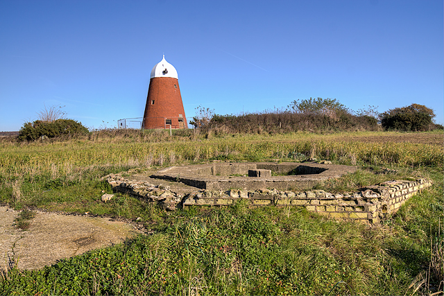
The remains of the first of four separate HFDF sites (I've numbered them 1 to 4 for identification purposes) can be found to the south of the windmill. The octagonal brick blast wall that once protected the wooden tower has vanished, although traces of the brickwork are still visible around the tower's concrete foundations. There is also a rectangular concrete platform in front whose purpose is unknown, a corner of which is visible in the photo.
SU9109 : Halnaker Hill WWII RDF station - HFDF #1
RDF Tower: DoB ID: not recorded
The remains of the first of four separate HFDF sites (I've numbered them 1 to 4 for identification purposes) can be found to the south of the windmill. The octagonal brick blast wall that once protected the wooden tower has vanished, although traces of the brickwork are still visible around the tower's concrete foundations. There is also a rectangular concrete platform in front whose purpose is unknown, a corner of which is visible in the photo.
SU9109 : Halnaker Hill WWII RDF station - HFDF #1
 Map © Crown Copyright")
TIP: Click the map for more Large scale mapping
- Grid Square
- SU9109, 23 images (more nearby 🔍)
- Photographer
- Mike Searle (more nearby)
- Date Taken
- Friday, 17 November, 2017 (more nearby)
- Submitted
- Saturday, 18 November, 2017
- Subject Location
-
OSGB36:
 SU 9197 0960 [10m precision]
WGS84: 50:52.7152N 0:41.6467W - Camera Location
-
OSGB36: SU 9196 0959
- View Direction
- East-northeast (about 67 degrees)