TG2142 : Cromer Pier
taken 7 years ago, near to Cromer, Norfolk, England
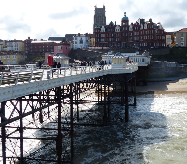
Cromer Pier is a Grade II listed seaside pier Link
. The pier is the home of the Cromer Lifeboat Station and the Pavilion Theatre.
In 1902, the pier was completed and opened to the public. The pier was designed by Douglass and Arnott and the construction was carried out by Alfred Thorne. The pier is 450 feet long and cost £17,000 to build. In the early years the pier consisted of glass-screened shelters and a bandstand on the end of the pier. The shelters were roofed over in 1905 to form a pavilion; the bandstand was later replaced with a stage and arch.
The Church of St Peter and St Paul has the highest church tower in Norfolk. It is 160 feet high and served as a navigational mark until 1719 when the first lighthouse was built.
The steps to the top of the tower become very high and steep when you get near the top, so, although the climb is worth it, it is not for the weak or faint-hearted.
 Map © Crown Copyright")
- Grid Square
- TG2142, 1251 images (more nearby 🔍)
- Photographer
- Mat Fascione (more nearby)
- Date Taken
- Saturday, 16 September, 2017 (more nearby)
- Submitted
- Saturday, 9 December, 2017
- Subject Location
-
OSGB36:
 TG 219 424 [100m precision]
WGS84: 52:55.9962N 1:18.0662E - Camera Location
-
OSGB36: TG 219 424
- View Direction
- SOUTH (about 180 degrees)