HY2913 : Ring of Brodgar
taken 6 years ago, near to Sultigeo, Mainland, Orkney Islands, Scotland
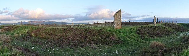
The Ring of Brodgar is one of the chief sites of Neolithic Orkney. Like the nearby Stones of Stenness it is categorised as a "Henge" monument - that is to say a type of Neolithic earthwork consisting of a circular or oval bank with an internal ditch within which there is a central flat area, the whole exceeding 20m (66 ft) diameter.
The ring is thought to have been erected between 2500 and 2000 BC (4-4½ thousand years ago) making it perhaps a thousand years younger than the nearby Stones of Stenness.
With a diameter of 103.6 metres (340 ft), the Brodgar ring is the third largest stone circle in the British Isles (after the outer ring of stones at Avebury and the Greater Ring at Stanton Drew). Interestingly, Brodgar is exactly the same size as Avebury's two inner rings.
The area covered by the Ring of Brodgar is c. 8,435m² (just over 2 acres)
The Ring of Brodgar forms part of the UNESCO Heart of Neolithic Orkney World Heritage Site Link- Its inclusion gaining the remark "The Ring of Brodgar is the finest known truly circular late Neolithic or early Bronze Age stone ring and a later expression of the spirit which gave rise to Maeshowe, Stenness and Skara Brae."
Canmore website page with technical information and photographs here:
Link
Detailed Map (Plan of ring): Link
 Map © Crown Copyright")
- Grid Square
- HY2913, 251 images (more nearby 🔍)
- Photographer
- Anne Burgess (more nearby)
- Date Taken
- Monday, 11 June, 2018 (more nearby)
- Submitted
- Friday, 22 June, 2018
- Subject Location
-
OSGB36:
 HY 2944 1337 [10m precision]
WGS84: 59:0.0949N 3:13.7970W - Camera Location
-
OSGB36: HY 29450 13432
- View Direction
- SOUTH (about 180 degrees)