G6173 : Muckross Head EIRE Sign
taken 6 years ago, 3 km from Kilcar, Co Donegal, Ireland
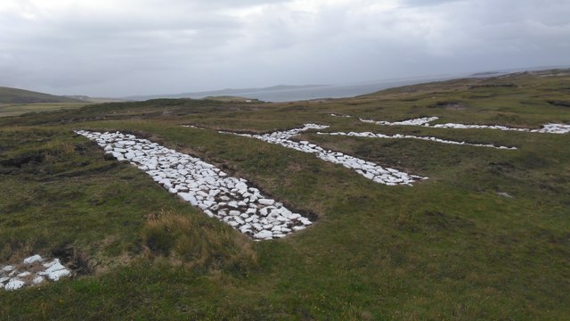
Muckross Head EIRE Sign
EIRE laid out in white painted stones as it would have been during WWII. These were coastal markers showing the neutral coastline of Ireland. They also acted as navigation markers for pilots. This was recently restored and does not have a number. Number 71 is located at Sliabh Liag and 70 at St. John's Point.
![Creative Commons Licence [Some Rights Reserved]](https://s1.geograph.org.uk/img/somerights20.gif)
|
· Find out How to reuse this image ·
Share:
|
|||||
| Start a discussion on G6173 | Suggest an update to this image | Contact the contributor | |||
Loading map... (JavaScript required)
- Grid Square
- G6173, 13 images (more nearby
 )
)
- Photographer
- Daragh McDonough (find more nearby)
- Date Taken
- Monday, 18 June, 2018 (more nearby)
- Submitted
- Wednesday, 29 August, 2018
- Geographical Context
- Primary Subject of Photo
- Subject Location
-
Irish:
 G 6186 7348 [10m precision]
WGS84: 54:36.4863N 8:35.4590W - Camera Location
-
Irish: G 6186 7348
- View Direction
- EAST (about 90 degrees)
This page has been viewed about 126 times.
View this location:
KML (Google Earth) ·
Google Maps ·
Bing Maps ·
Geograph Coverage Map ·
More Links for this image
·
Bing Maps ·
Geograph Coverage Map ·
More Links for this image