J3474 : The Queen Elizabeth Bridge, Belfast (2)
taken 16 years ago, near to Belfast, Co Antrim, Northern Ireland
This is 1 of 5 images, with title starting with The Queen Elizabeth Bridge, Belfast in this square
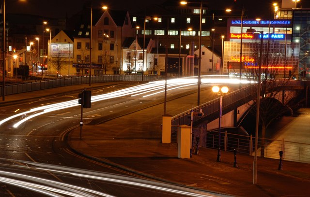
The Queen Elizabeth Bridge, Belfast (2)
See J3474 : The Queen Elizabeth Bridge, Belfast. The bridge at night. The headlight streaks, at the bottom, are caused by traffic turning right before crossing the Queens Bridge J3474 : The Queen's Bridge, Belfast. The exposure was about 20 seconds creating the illusion that both streams of traffic are moving at the same time.
The Queen Elizabeth Bridge, Belfast
The Queen Elizabeth bridge, across the River Lagan, opened in 1966. Part of a one-way system, it is used by outward traffic heading towards the Sydenham bypass (for north Down), east Belfast, Newtownards and the Ards Peninsula.
![Creative Commons Licence [Some Rights Reserved]](https://s1.geograph.org.uk/img/somerights20.gif)
|
· Find out How to reuse this image ·
Share:
|
|||||
|
There are 4 posts in a
discussion on J3474 (preview on the left) |
Suggest an update to this image | Contact the contributor | |||
Loading map... (JavaScript required)
- Grid Square
- J3474, 4349 images (more nearby
 )
)
- Photographer
- Albert Bridge (find more nearby)
- Date Taken
- Tuesday, 4 December, 2007 (more nearby)
- Submitted
- Wednesday, 5 December, 2007
- Category
- Bridge (more nearby)
- Subject Location
-
Irish:
 J 344 744 [100m precision]
WGS84: 54:36.0072N 5:55.2202W - Camera Location
-
Irish: J 345 744
- View Direction
- West-southwest (about 247 degrees)
Image classification(about):
Geograph
This page has been viewed about 280 times.
View this location:
KML (Google Earth) ·
Google Maps ·
Bing Maps ·
Geograph Coverage Map ·
More Links for this image
·
Bing Maps ·
Geograph Coverage Map ·
More Links for this image