O1434 : Mellow Bridge and River Liffey
taken 6 years ago, near to Dublin, Ireland
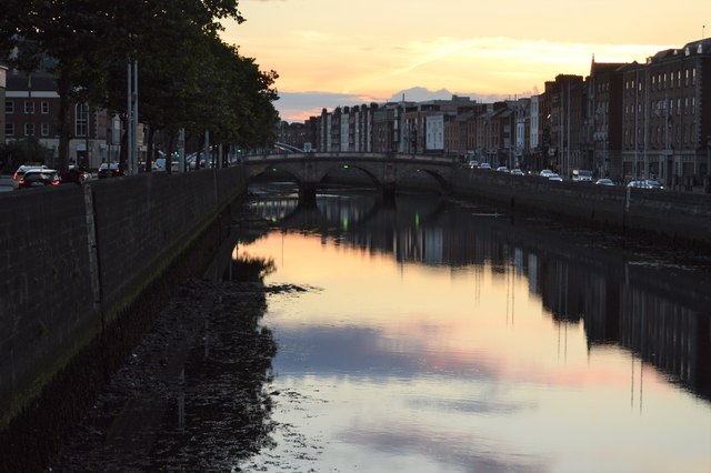
Mellows Bridge is a road bridge spanning the River Liffey, in Dublin, and joining Queen Street and Arran Quay to the south quays.
Designed by Charles Valency (a military engineer) a replacement bridge on the same site was built between 1764 and 1768 as a three elliptical arch stone bridge with a total span of 42 m, and named Queens Bridge after Charlotte of Mecklenburg, queen consort of George III.
The bridge was renamed for the legendary Queen Maeve at a meeting of the Municipal Council on 2 January 1922. However, it was renamed again in 1942 to its current name, after Lieutenant General Liam Mellows Irish Republican army who was executed during the Irish Civil War.
Being 250 years old, Mellow's Bridge remains the oldest of all Dublin city bridges still in use, although the parapets were replaced with cast iron balustrades and stone copings between 1816 and 1818.
The River Liffey flows through the centre of Dublin. Its major tributaries include the River Dodder, the River Poddle and the River Camac. The river supplies much of Dublin's water and a range of recreational activities. It rises in The Wicklow Mountains and flows 125km.
![Creative Commons Licence [Some Rights Reserved]](https://s1.geograph.org.uk/img/somerights20.gif)
|
· Find out How to reuse this image ·
Share:
|
|||||
| Start a discussion on O1434 | Suggest an update to this image | Contact the contributor | |||
- Grid Square
- O1434, 217 images (more nearby
 )
)
- Photographer
- N Chadwick (find more nearby)
- Date Taken
- Friday, 3 August, 2018 (more nearby)
- Submitted
- Wednesday, 25 March, 2020
- Geographical Context
- Subject Location
-
Irish:
 O 147 342 [100m precision]
WGS84: 53:20.7549N 6:16.7002W - Camera Location
-
Irish: O 148 341
- View Direction
- West-northwest (about 292 degrees)