J4892 : Whitehead to Blackhead (5)
taken 16 years ago, near to Whitehead, Co Antrim, Northern Ireland
Whitehead to Blackhead (5)
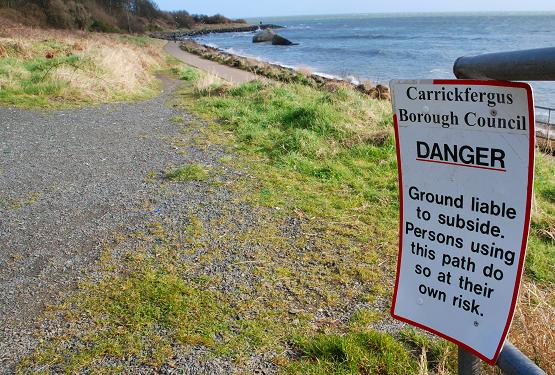
See J4792 : Whitehead to Blackhead (4). Where the inland and coastal paths meet. Note the at own risk sign. Continue to J4892 : Whitehead to Blackhead (6).
The Blackhead Path, Whitehead
A path running from The Banks at Whitehead, along the shore, to the Blackhead Lighthouse (with a parallel path running inland along the cliff and higher ground). It is possible to walk back to Whitehead from the lighthouse, on a surfaced path, via Muldersleigh Hill, McCreas Brae and the Islandmagee Road. Steep in places and not suitable for wheelchairs.
![Creative Commons Licence [Some Rights Reserved]](https://s1.geograph.org.uk/img/somerights20.gif)
|
· Find out How to reuse this image ·
Share:
|
|||||
| Start a discussion on J4892 | Suggest an update to this image | Contact the contributor | |||
Loading map... (JavaScript required)
- Grid Square
- J4892, 33 images (more nearby
 )
)
- Photographer
- Albert Bridge (find more nearby)
- Date Taken
- Friday, 22 February, 2008 (more nearby)
- Submitted
- Friday, 22 February, 2008
- Category
- Path > Path (more nearby)
- Subject Location
-
Irish:
 J 4813 9262 [10m precision]
WGS84: 54:45.5795N 5:41.9769W - Camera Location
-
Irish: J 4809 9261
- View Direction
- East-northeast (about 67 degrees)
Image classification(about):
Geograph
This page has been viewed about 164 times.
View this location:
KML (Google Earth) ·
Google Maps ·
Bing Maps ·
Geograph Coverage Map ·
More Links for this image
·
Bing Maps ·
Geograph Coverage Map ·
More Links for this image