Public Tags
Other tags: Tower House
building:Tower House
Showing latest 50 of 100 images tagged with ruin:Tower House tag.
|
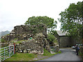
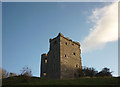
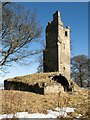
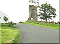
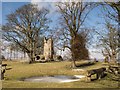
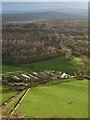
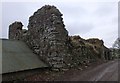
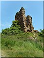
The 'old hall' at Old Hall Farm
by Karl and Ali geograph for square SD1892 We did not see anyone around to ask about this ruin but it looks like the... (more)
Tags:
former:Country LaneX
top:Defence, MilitaryX
top:Derelict, DisusedX
Fortified Tower HouseX
top:Historic Sites and ArtefactsX
Pele TowerX
top:Roads, Road TransportX
Ruined TowerX
ruin:Tower House
top:UplandsX
|

|
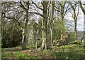
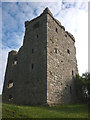
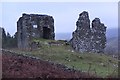
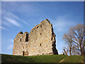
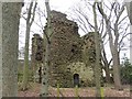
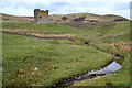
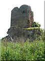
Langshaw Tower ruin
by Astrid H geograph for square NT5139 From this point the three tower houses in Langshaw village are clearly visible:... (more)
Tags:
top:Historic Sites and ArtefactsX
ruin:Tower House
|
|
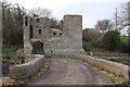
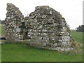
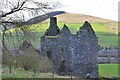
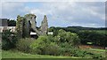
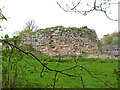
Remains of Lamington Tower
by Alan O'Dowd geograph for square NS9831 Lamington Tower was a medieval tower house, probably built in the late sixteenth... (more)
Tags:
type:GeographX
top:Historic Sites and ArtefactsX
Lamington TowerX
top:LowlandsX
subject:TowerX
Tower House
ruin:Tower House
top:Woodland, ForestX
|
|
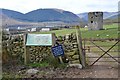
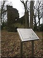
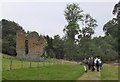
Dryhope Tower
by Jim Barton geograph for square NT2624 An information board and a welcoming sign for visitors to the ruins of this 16th... (more)
Tags:
top:Derelict, DisusedX
top:Farm, Fishery, Market GardeningX
FarmlandX
type:GeographX
top:GrasslandX
top:Historic Sites and ArtefactsX
Information BoardX
Peel Tower RuinsX
ruin:Tower House
|
|
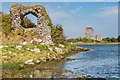
Mahee castle, Strangford Lough
by Albert Bridge geograph for square J5263 Category: Tower house Mahee (also known as Nendrum) castle is a tower house built in 1570. It... (more)
|
|
Evening at Arnside Tower
by Karl and Ali geograph for square SD4576 The ruined tower house seen from the north on a fine autumn evening.
|
|
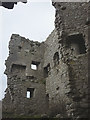
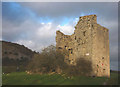
Arnside Tower - the northern angle
by Karl and Ali geograph for square SD4576 This is the best preserved aspect of this imposing tower house.
Tags:
top:Derelict, DisusedX
top:Historic Sites and ArtefactsX
top:LowlandsX
Medieval Tower HouseX
Ruined Pele TowerX
ruin:Tower House
|
|
Westhall Farm Tower House
by M J Richardson geograph for square NT0447 The remains of a medieval tower house [ca 16thC] adjacent to the farm.
Tags:
16th CenturyX
type:GeographX
top:GrasslandX
top:Historic Sites and ArtefactsX
top:LowlandsX
Medieval TowerX
subject:RuinX
place:South LanarkshireX
ruin:Tower House
near:WalstonX
|
|
Westhall Farm Tower House
by M J Richardson geograph for square NT0447 The remains of a medieval tower house [ca 16thC] adjacent to the farm.
Tags:
16th CenturyX
type:GeographX
top:Historic Sites and ArtefactsX
top:LowlandsX
Medieval TowerX
subject:RuinX
place:South LanarkshireX
ruin:Tower House
near:WalstonX
|
|
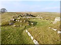
Staneyhill Tower, Hopetoun Estate
by Greg Fitchett geograph for square NT0978 The ruins of this early 17th century tower house is situated on a ridge in the... (more)
Tags:
top:Country EstatesX
top:Derelict, DisusedX
type:GeographX
top:Historic Sites and ArtefactsX
top:LowlandsX
ruin:Tower House
|
|
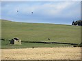
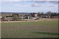
Burradon Tower and information panel
by Graham Robson geograph for square NZ2773 The ruins of Burradon Tower sit within a small wooded area adjacent to the farm... (more)
|
|
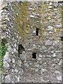
Arnside Tower interior
by Karl and Ali for square SD4576 The tower dates back to the 14th Century and once had four floors connected by... (more)
Tags:
top:Derelict, DisusedX
top:Historic Sites and ArtefactsX
top:Housing, DwellingsX
Interior DetailX
Ruined Pele TowerX
ruin:Tower House
|
|
Elibank Castle
by Jim Barton geograph for square NT3936 A late 16th century tower house, which was known to be in ruins in 1722 - see... (more)
|
|
Ruin and Dunguaire Castle
by Ian Capper geograph for square M3710 Looking towards Dunguaire Castle from the ruins of the Castle of Doon on an... (more)
Tags:
top:CoastalX
place:Dungory CastleX
place:Dunguaire CastleX
top:Historic Sites and ArtefactsX
place:KinvaraX
RuinX
Tower House
|
|
Kilnsike Tower
by Richard Webb for square NT6313 Ruined tower house.
|
|
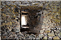
Mahee/Nendrum Castle (interior) (2)
by Albert Bridge for square J5263 See J5263 : Mahee/Nendrum Castle (interior) (1). The window on the right in the link. Note the exceptionally thick wall.
|
|
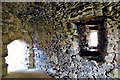
Mahee/Nendrum Castle (interior) (1)
by Albert Bridge for square J5263 See J5263 : Mahee castle, Strangford Lough. Part of the ground floor of the premises. The upper floors are... (more)
|
|
Wreaths Tower
by Ann Cook geograph for square NX9556 This tower house is believed to have belonged to the Regent Morton who was... (more)
Tags:
top:Historic Sites and ArtefactsX
ruin:Tower House
|
|
Buckholm Tower, Galashiels
by Jim Barton geograph for square NT4837 The ruined 16th century tower house against the background of Meigle Hill.
|
|
Track past Nether Horsburgh Tower
by Jim Barton geograph for square NT3039 The track up by the Hope Burn passes this ruined 16th century tower house - see... (more)
|
|
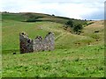
Dykeraw Tower
by Richard Webb geograph for square NT6209 A very low ruin of a tower house at Southdean.
|
|
Thirlwall Castle
by Karl and Ali geograph for square NY6566 I wondered where Hadrian's Wall went to ....... It's a fair bet that... (more)
Tags:
ruin:CastleX
top:Defence, MilitaryX
top:Derelict, DisusedX
Fortified Tower HouseX
top:GrasslandX
top:Historic Sites and ArtefactsX
MediaevalX
period:MedievalX
Pele TowerX
ruin:Tower House
top:UplandsX
|
|
Whitton Tower
by Richard Webb geograph for square NT7522 A 17th century tower house ruin amongst the buildings of a large modern farm.
|
|
Fulton Tower
by Oliver Dixon geograph for square NT6015 The remains of a 16th century tower house.
|
|
Fisher's Tower
by Astrid H geograph for square NT5334 The ruin of Fisher's tower is situated in the grounds of nearby Darnick Tower.
Tags:
top:Historic Sites and ArtefactsX
ruin:Tower House
|
|
Staneyhill Tower, Hopetoun Estate
by Greg Fitchett geograph for square NT0978 The early 17th century ruins of Staneyhill Tower is situated in the South Deer... (more)
Tags:
top:Country EstatesX
top:Derelict, DisusedX
type:GeographX
top:GrasslandX
top:Historic Sites and ArtefactsX
top:LowlandsX
Sport Eventing EquestrianX
top:Sport, LeisureX
ruin:Tower House
|
|
Burradon Tower
by Graham Robson geograph for square NZ2773 The remains of an old fortified house in a copse adjacent to the farm steading... (more)
|
|
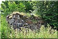
Remains of Dally Castle
by Oliver Dixon geograph for square NY7784 Possibly dating from the 13th century, originally a "hall house",... (more)
Tags:
type:GeographX
Grass MoorlandX
top:Historic Sites and ArtefactsX
top:MoorlandX
subject:RuinX
RuinX
Tower House
|
|
Remains of Dally Castle
by Oliver Dixon geograph for square NY7784 Possibly dating from the 13th century, originally a "hall house",... (more)
Tags:
Electricity Transmission PoleX
top:Energy InfrastructureX
type:GeographX
Grass MoorlandX
top:Historic Sites and ArtefactsX
top:MoorlandX
RuinX
subject:RuinX
Tower House
|
|
Arnside Tower and Farm
by Karl and Ali for square SD4576 An almost aerial view from the southern scarp of the Knott. Beyond the Tower is... (more)
Tags:
FarmX
top:Farm, Fishery, Market GardeningX
top:GrasslandX
top:Historic Sites and ArtefactsX
top:LowlandsX
Ruined Pele TowerX
ruin:Tower House
top:Woodland, ForestX
|
|
Door, Redhouse Castle
by Richard Webb for square NT4677 A ruined tower house, now beside a garden centre and cafe.
|
|
Westhall Farm Tower House
by M J Richardson geograph for square NT0447 The remains of a medieval tower house [ca 16thC] adjacent to the farm - little... (more)
Tags:
16th CenturyX
type:GeographX
top:Historic Sites and ArtefactsX
top:LowlandsX
Medieval TowerX
place:South LanarkshireX
Then and NowX
subject:TowerX
ruin:Tower House
|
|
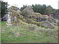
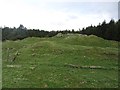
Remains of Kyle Castle
by Alan O'Dowd geograph for square NS6419 This wall and the flat-topped promontory on which it stands are all that remains... (more)
|
|
Dryhope Tower from the south
by Jim Barton geograph for square NT2624 Seen from the track past Dryhope farm.
Tags:
BurnX
type:GeographX
top:GrasslandX
top:Historic Sites and ArtefactsX
Peel Tower RuinsX
top:Rivers, Streams, DrainageX
ruin:Tower House
|
|
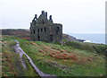
Baltersan Castle
by Mary and Angus Hogg geograph for square NS2808 Located on high ground above Abbeymill Burn, this 16th century tower house was... (more)
Tags:
top:Derelict, DisusedX
top:Farm, Fishery, Market GardeningX
top:Historic Sites and ArtefactsX
top:LowlandsX
ruin:Tower House
|
|
Arnside Tower on Christmas Eve
by Karl and Ali geograph for square SD4576 Briefly illuminated by a shaft of sunlight borne on the strong winds off the... (more)
Tags:
top:Defence, MilitaryX
top:Derelict, DisusedX
top:Historic Sites and ArtefactsX
top:LowlandsX
Ruined Pele TowerX
SunlightX
ruin:Tower House
|
|
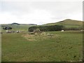
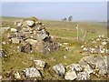
Ruins of Gamescleuch Tower
by Jim Barton geograph for square NT2814 A doorway on the NE side of this 16th century tower, which is now within a... (more)
Tags:
top:Historic Sites and ArtefactsX
ruin:Tower House
|
|
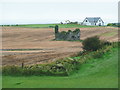
Ruined tower at Windydoors
by Jim Barton geograph for square NT4339 The remains of a 16th century fortified tower around which the farm has grown... (more)
|
|
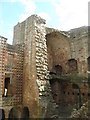
Staircase, Eden Castle
by Richard Webb for square NJ6958 Detail of the ruined 16th century tower house.
|
|
Couthalley Castle
by Richard Webb geograph for square NS9748 Earthworks and low ruins of a tower house. This was a landmark from West Coast... (more)
Tags:
top:Derelict, DisusedX
top:Historic Sites and ArtefactsX
RuinX
Tower House
top:Woodland, ForestX
|

|
Old Buckholm
by Richard Webb for square NT4837 A ruined tower house and later farm.
|
|
Redhouse
by Richard Webb for square NT4677 Ruined tower house, a landmark on the East Coast Main Line.
Tags:
type:Cross GridX
top:Derelict, DisusedX
railway:East Coast Main LineX
railway:ECM8X
top:Farm, Fishery, Market GardeningX
top:Historic Sites and ArtefactsX
railway:North British RailwayX
RailwayEastX
RuinX
Tower House
|
|
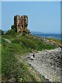
Dunskey Castle from the north-west
by Humphrey Bolton geograph for square NX0053 This is a ruined mid-16C tower house, which was abandoned and derelict by the 18C.
Tags:
subject:CastleX
Coast PathX
top:CoastalX
type:GeographX
top:GrasslandX
top:Historic Sites and ArtefactsX
top:PathsX
ruin:Tower House
|
|
Corsewall Castle
by Humphrey Bolton geograph for square NW9971 A Ruined 15C tower house.
Tags:
subject:CastleX
top:Farm, Fishery, Market GardeningX
type:GeographX
top:Historic Sites and ArtefactsX
top:LowlandsX
ruin:Tower House
|
|
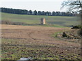
Corsbie Tower
by M J Richardson geograph for square NT6043 The remains of a 16thC tower house, on a raised mound. This monument has been... (more)
Tags:
16th CenturyX
top:Farm, Fishery, Market GardeningX
type:GeographX
Historic ScotlandX
top:Historic Sites and ArtefactsX
LauderdaleX
place:Scottish BordersX
Stubble FieldX
subject:TowerX
ruin:Tower House
TreesX
top:UplandsX
top:Woodland, ForestX
|
|
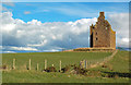
Seafield Tower
by Richard Sutcliffe geograph for square NT2788 The remains of a red sandstone tower house which was the residence of the... (more)
Tags:
top:CoastalX
top:Derelict, DisusedX
type:GeographX
top:Historic Sites and ArtefactsX
ShoreX
subject:TowerX
ruin:Tower House
Zoomed PictureX
|
|
Seafield Tower
by Richard Sutcliffe geograph for square NT2788 The remains of a red sandstone tower house which was the residence of the... (more)
Tags:
top:CoastalX
top:Derelict, DisusedX
type:GeographX
top:Historic Sites and ArtefactsX
subject:TowerX
ruin:Tower House
|
|
Seafield Tower
by Richard Sutcliffe geograph for square NT2788 The remains of a red sandstone tower house which was the residence of the... (more)
Tags:
top:CoastalX
top:Derelict, DisusedX
type:GeographX
top:Historic Sites and ArtefactsX
subject:TowerX
ruin:Tower House
|
|
Wallace's Tower, Roxburgh
by Jim Barton geograph for square NT7030 The remains of a 16th-century tower house on the west bank of the River Teviot.... (more)
Tags:
16th Century BuildingX
top:Derelict, DisusedX
top:Farm, Fishery, Market GardeningX
FarmlandX
type:GeographX
top:Historic Sites and ArtefactsX
ruin:Tower House
|
|
Crichton Castle tower house
by M J Richardson for square NT3861 Part of the original tower house, around which the castle was subsequently... (more)
Tags:
period:14th CenturyX
Crichton CastleX
top:Historic Sites and ArtefactsX
top:LowlandsX
place:MidlothianX
ruin:Tower House
|