Exploring SD9923
![Creative Commons Licence [Some Rights Reserved]](https://s1.geograph.org.uk/img/somerights20.gif)
Great Britain 1:50 000 Scale Colour Raster Mapping Extracts © Crown copyright Ordnance Survey. All Rights Reserved. Educational licence 100045616.
Contents
Introduction
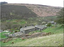
This square includes the lower end of the Withens Clough valley, with a very steep hillside on the south side and quite a steep hillside on the north side that goes up and up, and being south-facing has some farms and houses. The public rights of way are prefixed by 'Hebden Royd', and their numbers are given here prefixed by FP for footpath.Church Bank Lane
[map SD 9999 2322]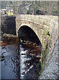
The natural place to start exploring this square is Marshaw Bridge. This ancient crossing of Cragg Brook (mentioned in 1316 (Calderdale Companion)), just below the confluence of Turvin Clough and Withens Clough, is just outside of the square. This lane is part of the Calderdale Way.
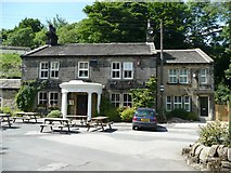
The Hinchliffe Arms is on the north side of the lane. It was called the Cragg Vale Inn until 1912, when it was renamed after the Hinchliffe family, one of the principal owners of mills in Cragg Vale. (Calderdale Companion)
A house in late 19C style is attached to the east side of the public house, and FP117 passes it on its way to Sunny Bank Lane. It is a well-used easy path mostly through woodland.
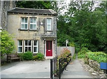
Tenter Hill Lane goes off to the south, after crossing Withens Clough over Bod Bridge. The lane is a private road and public footpath, FP118. At the foot of the lane, Marsh Grove is a Grade II listed house once owned by the Hinchliffe family. It was converted to cottages but is now a single house again. It was built in the early 19C, and has a first-floor 'taking in' door, now blocked to form a window.
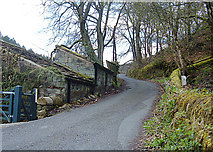
100m up Tenter Hill Lane a stile on the left leads to FP119, a well-used easy path up Turvin Clough, mostly through Higher House Wood.
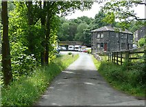
Where Church Bank Lane bends uphill to the right, a private driveway continues straight on. This led to Vale Mill (on the 1895 map, Rud Clough Mill (Cotton) on the 1850 map) and also Upper Mill, originally New Mill (Cotton). Vale Mill was destroyed by fire in 1896 and Upper Mill likewise in 1900.
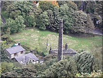
A chimney of Vale Mill survives.
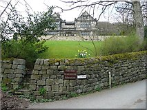
Church Bank Lane ends at the junction with Rud lane and the lane to Old Cragg Hall. This is the end of the adopted highway. This image shows the Old (former) Vicarage, which is Grade II listed and has a date-stone inscribed 'To the Glory of God and in loving memory of Hinchliffe Hinchliffe esq. J.P. of Cragg Hall in this parish this Vicarage house is erected by his daughter Helen Strickland, A. D. 1901'. In the foreground a sign for the Old Cragg Hall lane 'private road / no vehicular access / walkers welcome'. It is FP82, and leads to Hill Top Lane and Swine Market Lane beyond Old Cragg Hall.
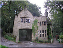
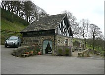
Looking up the Old Cragg Hall lane, you cannot miss seeing this remarkable Cragg Hall gatehouse built in Arts and Crafts style in 1906 and Grade II listed. This was designed by Edgar Wood; Cragg Hall itself was destroyed by fire in 1921 (Edgar Wood Heritage group).
Rud Lane
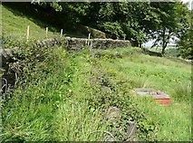
Rud Lane has somehow avoided being photographed, but there is a glimpse of it in this image. It is an ancient bridleway, part of a route from Halifax to Rochdale. It is now an unadopted road leading to Withens Clough Reservoir, where there is a car park (currently closed due to engineering works) and also to Withens Lane, which leads to several properties on the hillside. Rud Lane is another FP82, and also part of the Calderdale Way. The valley and southern hillside of Withens Clough have also escaped being photographed ... so far.
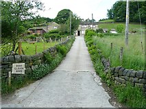
A branch of FP82 goes up the driveway of Rudd Clough Farm (formerly called Rud Clough) and then turns right to a sharp bend on the Old Cragg Hall lane.
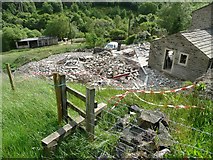
This path was affected, but not blocked, by building works during 2012.
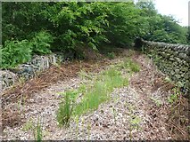
The north-eastern part of the path is on a raised terrace above the field, and could do with more usage to keep the vegetation down.
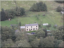
Rudd Clough Farm is typical of the many small hill farms that are being converted to small groups of houses.
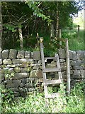
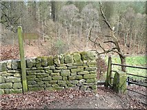
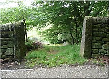
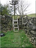
The second branch of FP82 along Rud Lane starts at this ladder stile, 500m up the lane.
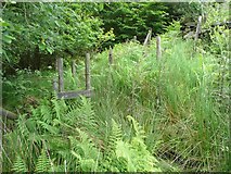
This is an explorer's path. After crossing a very wet field, the path is soon hemmed in by a wall and fence.

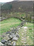
Somehow the path manages to combine a very steep gradient with very thick mud. There is a barbed wire fence on the western side and a stone wall on the eastern side with some boulders and tufts of grass to give an occasional firm foot-hold.
The top end of the path runs up a field access track.
The entrance to the path at Swine Market Lane looks so innocent!
[map SD 9936 2347]
The lane to Old Cragg Hall
[map SD 9972 2332]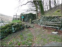
The lane zig-zags up the steep hillside, and this is the first sharp bend, with a welcome seat. There are stiles to two footpaths here. The one on the left is the one to Rudd Clough farm, already described. The one on the right is a shortcut to Swan Bank Farm. Continuing up the lane, there is a junction where one branch bends sharply left through a wood, and the other keeps straight on to Old Cragg Hall.

The path to Swan Bank is another one sharing the number 82. It is a fairly easy path starting along the bottom of Rud Clough Wood and then running along a terrace above the field, rather like the one on the Rudd Clough Farm path.
The path then turns straight up the hillside, paved with very worn stone steps.
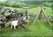
There is a ladder stile up to the lane to Swan Bank. This is now called Swine Market Lane; logically it should be Swan Bank Lane but the 1850 map captions it as part of Hill Top Lane whereas one would expect that name to go down to the junction near Cragg Old Hall.
[map SD 9983 2351]

Old Cragg Hall is Grade II listed, and is dated 1617. It has been sensitively extended in the early 20C, including a wing dated 1933.
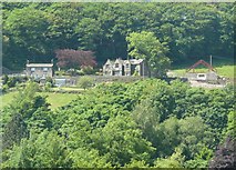
Here is Old Cragg Hall in its hillside setting. Notice the building under construction to the right of the Hall.
The new building is a holiday cottage. A public footpath (FP87) goes past the Hall and behind the cottage.
This footpath is a field path that goes along the hillside, then turns through a right-angle via this stile to go up the hillside to join a path from Hill Top Farm that we will meet later.
[map SD 9990 2381]
Great Britain 1:50 000 Scale Colour Raster Mapping Extracts © Crown copyright Ordnance Survey. All Rights Reserved. Educational licence 100045616.
( Page 1 2 next >> )