Lomond Hills Regional Park
![Creative Commons Licence [Some Rights Reserved]](https://s1.geograph.org.uk/img/somerights20.gif)
Contents
Holl Reservoir page 2
There is a walkway over the dam and a faint grassy path on the other side which ultimately leads to the road over the hills between Falkland and Leslie. From this point the main track turns right, circles Drumain Reservoir and returns to the bridge NO2204 : Bridge on road to Harperleas Reservoir, Lomond Hills
See Lomond Hills Regional Park article Link
See Lomond Hills Regional Park article Link
by Bill Kasman
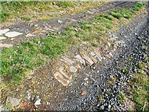
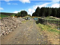
A closer look at this track NO2204 : Track in Lomond Hills shows that it once had a better surface than it currently does.
See Lomond Hills Regional Park article Link
See Lomond Hills Regional Park article Link
by Bill Kasman
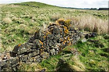
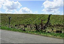
To one side of the track not far past this junction NO2204 : Post on track to Harperleas Reservoir, Lomond Hills can be found this short section of wall. It looks too well built to be a field boundary or a sheep fank and may be all that remains of a house. This is not the only building remains in the park and they are a reminder that these hills were once populated and busy. The limekilns near East Lomond NO2305 : Damage to information boards at limekilns, Lomond hills and the numerous disused quarries in the park are also testament to this. The remains of a field boundary wall can be seen in the background and it is nowhere near as well built as this section of wall the stones of which have clearly been cemented in place.
See Lomond Hills Regional Park article Link
See Lomond Hills Regional Park article Link
by Bill Kasman
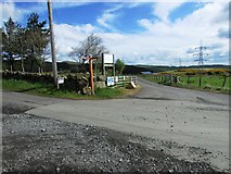
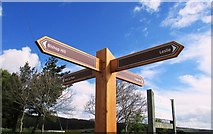
The road to Holl Reservoir reaches this crossroads NO2203 : West Balgothrie Farmhouse, Lomond Hills Like many junctions in the park it is well signposted NO2203 : Signpost at crossroads, Lomond Hills
See Lomond Hills Regional Park article Link
See Lomond Hills Regional Park article Link
by Bill Kasman
Most junctions in the park are well signposted NO2203 : Crossroads on road to Holl Reservoir, Lomond Hills
See Lomond Hills Regional Park article Link
See Lomond Hills Regional Park article Link
by Bill Kasman
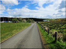
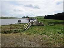
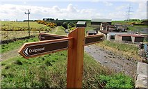
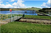
This road leads past Holl Reservoir and the water treatment works to a rough path which eventually connects with the road over the hills between Falkland and Leslie not far from Craigmead car park NO2206 : Craigmead car park, Lomond hills The car park of Lomond Hills Fishery is on the left. The reservoir dam is also on the left just out of shot.
See Lomond Hills Regional Park article Link
See Lomond Hills Regional Park article Link
by Bill Kasman
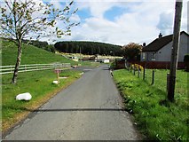
The water treatment works are straight ahead. There are two cottages on the right.
See Lomond Hills Regional Park article Link
See Lomond Hills Regional Park article Link
by Bill Kasman
Past the water treatment works NO2203 : Approaching water treatment works, Lomond Hills the path crosses this bridge and progresses straight ahead through the gap in the trees. Just past the bridge there is a path which leads to Leslie.
See Lomond Hills Regional Park article Link
See Lomond Hills Regional Park article Link
by Bill Kasman
Just past the bridge in this image NO2203 : Path past water treatment works, Lomond Hills is this signpost.
The buildings are part of the water treatment works.
See Lomond Hills Regional Park article Link
The buildings are part of the water treatment works.
See Lomond Hills Regional Park article Link
by Bill Kasman
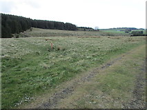
Past the water treatment works NO2203 : Path past water treatment works, Lomond Hills the path ahead climbs gently through Balgothrie Woods to connect with the road over the hills from Falkland to Leslie. The path to the left connects with another path heading for Drumain Reservoir but the going is difficult and not recommended (there is an alternative - NO2304 : Path on Lomond Hills).
See Lomond Hills Regional Park article Link
See Lomond Hills Regional Park article Link
by Bill Kasman
Looking back from a few metres up this track NO2203 : Path to Craigmead car park, Lomond Hills gives a view of the water treatment works near Holl Reservoir.
See Lomond Hills Regional Park article Link
See Lomond Hills Regional Park article Link
by Bill Kasman
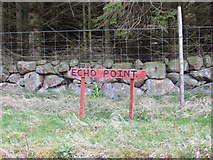
On the path from the water treatment works to Craigmead I found this sign but try as I might I couldn't elicit any semblance of an echo. Maybe I just don't have the lung power for it!
See Lomond Hills Regional Park article Link
See Lomond Hills Regional Park article Link
by Bill Kasman
The path from Holl Reservoir which passes the water treatment works NO2203 : Road to water treatment works, Lomond Hills continues towards Balgothrie Farm and ultimately to Craigmead car park. The signpost points the way to a rough path through the woods to Drumain Reservoir NO2304 : Path to Drumain Reservoir, Lomond Hills.
See Lomond Hills Regional Park article Link
See Lomond Hills Regional Park article Link
by Bill Kasman
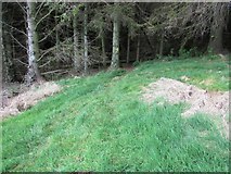
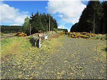
The path indicated by this signpost NO2304 : Path on Lomond Hills disappears into the trees heading for Drumain Reservoir. This path is quite rough and indistinct at times and probably isn't the wisest choice for anyone looking for a pleasant Sunday afternoon stroll although it is waymarked by yellow arrows painted on the trees.
See Lomond Hills Regional Park article Link
See Lomond Hills Regional Park article Link
by Bill Kasman
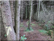
Once into the woods this path becomes difficult to follow. Fortunately the ranger service have painted yellow arrows on the trees!
See Lomond Hills Regional Park article Link
See Lomond Hills Regional Park article Link
by Bill Kasman
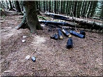
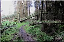
On the path through the woods to Drumain Reservoir NO2304 : Path to Drumain Reservoir, Lomond Hills I found these burnt logs. Whoever did this was acting in an irresponsible manner. Starting a fire in a woodland is not a good idea!
See Lomond Hills Regional Park article Link
See Lomond Hills Regional Park article Link
by Bill Kasman
The woodland path to Drumain Reservoir NO2304 : Path to Drumain Reservoir, Lomond Hills is rough but obviously maintained by the park ranger service. Note the yellow arrow pointing the way.
See Lomond Hills Regional Park article Link
See Lomond Hills Regional Park article Link
by Bill Kasman
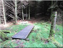
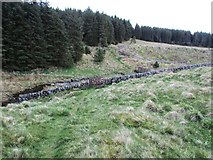
The path to Drumain Reservoir NO2204 : Footbridge in woodland, Lomond Hills is almost blocked by these fallen trees.
See Lomond Hills Regional Park article Link
See Lomond Hills Regional Park article Link
by Bill Kasman
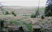
The rough woodland path to Drumain Reservoir NO2304 : Path to Drumain Reservoir, Lomond Hills eventually emerges from the woods at this footbridge over the Lothrie Burn which flows down from Ballo Reservoir (out of shot to the right). The hill just visible on the horizon right of centre is West Lomond.
See Lomond Hills Regional Park article Link
See Lomond Hills Regional Park article Link
by Bill Kasman
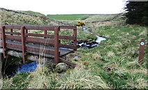
From the footbridge in this image NO2204 : Path to Drumain Reservoir, Lomond Hills can be seen the dam of Ballo Reservoir. The burn is the Lothrie Burn.
See Lomond Hills Regional Park article Link
See Lomond Hills Regional Park article Link
by Bill Kasman
Looking back to this footbridge NO2204 : Path to Drumain Reservoir, Lomond Hills over the Lothrie Burn. See also this image NO2204 : Path to Drumain Reservoir, Lomond Hills
See Lomond Hills Regional Park article Link
See Lomond Hills Regional Park article Link
by Bill Kasman
The circular path around Drumain Reservoir NO2204 : Post on track to Harperleas Reservoir, Lomond Hills passes a post marking the beginning of the rough path through the woods which leads to the path past the water treatment works NO2203 : Water treatment works, Lomond Hills
See Lomond Hills Regional Park article Link
See Lomond Hills Regional Park article Link
by Bill Kasman
The circular path around Drumain Reservoir NO2204 : Post on track to Harperleas Reservoir, Lomond Hills. Through the gate the path runs along the left hand side of the reservoir. Bishop Hill is visible on the horizon right of centre
See Lomond Hills Regional Park article Link
See Lomond Hills Regional Park article Link
by Bill Kasman
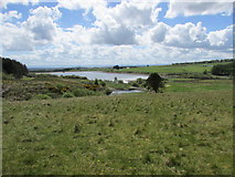
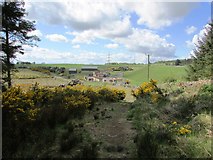
From the same position as this image NO2204 : Drumain Reservoir, Lomond Hills we see Holl Reservoir.
Link
Link
by Bill Kasman
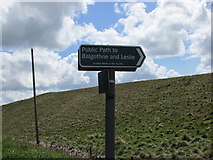
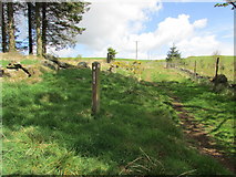
On the minor road which crosses the hills between Falkland and Leslie can be found this sign pointing to a public right of way. See also this image NO2305 : Path to Holl Reservoir, Lomond Hills.
See Lomond Hills Regional Park article Link
See Lomond Hills Regional Park article Link
by Bill Kasman
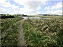
On the minor road over the hills from Falkland to Leslie is this faint but well signposted path. It joins the path which passes the water treatment works near Holl Reservoir NO2203 : Water treatment works, Lomond Hills. For a closer look at the signpost on the left see this image NO2305 : Scotways signpost, Lomond Hills
by Bill Kasman
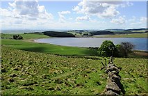
Further along this path NO2305 : Path to Holl Reservoir, Lomond Hills gives a view of Ballo Reservoir. The woods just left of centre are Balgothrie Woods through which the path past the water treatment works runs NO2203 : Water treatment works, Lomond Hills. This path can also be seen running along the near shore of the reservoir to eventually reach Craigmead car park.
See Lomond Hills Regional Park article Link
See Lomond Hills Regional Park article Link
by Bill Kasman
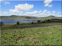
From the same position as this image NO2204 : Ballo Reservoir, Lomond Hills we see Bishop Hill, West Lomond and part of Ballo Reservoir.
See Lomond Hills Regional Park article Link
See Lomond Hills Regional Park article Link
by Bill Kasman
( Page < < prev 1 2 3 4 5 6 7 8 9 10 11 12 ... next >> )