10. K
My 2020 Coronavirus Lockdown walking project
![Creative Commons Licence [Some Rights Reserved]](https://s1.geograph.org.uk/img/somerights20.gif)
K
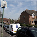
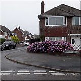
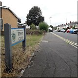
218. KEEBLE CLOSE
The first house of Keeble Close is pictured here, along with the main carriageway of Keeble Road. The little housing estate here was built in the later 1980s and is mainly, possibly all, social housing.
Keeble Close is signposted rather unusually, with the sign opposite rather than on its own corner, and of an unusual square design.
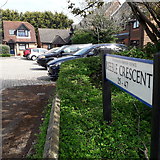
219. KEEBLE CRESCENT
Keeble Crescent is a curious name: It is indeed a crescent-shaped road off Keeble Road, but according to some maps only the offshoots leading to the houses are named Keeble Crescent, the actual crescent being part of Keeble Road.
The estate dates from the later 1980s on the site of a sports ground or similar.
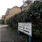
220. KEEBLE ROAD
Keeble Road always was a short cul-de-sac off Kinson Park Road, leading to a sports ground. In the later 1980s the sports ground was developed for housing and Keeble Road thus extended. Here, we are at the T-shaped end of the road, with odd numbers around the left arm and evens around the right.
Keeble Road always was a short cul-de-sac off Kinson Park Road, leading to a sports ground. In the later 1980s the sports ground was developed for housing and Keeble Road thus extended. Here, we are at the T-shaped end of the road, with odd numbers around the left arm and evens around the right.
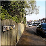
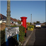
221. KING EDWARD AVENUE
One of three consecutive monarchical avenues in Moordown, King George and Queen Mary Avenues being parallel to the south. They comprise typical Moordown housing - decent detached houses from the reign of Edward and the Georges in the 20th century.
The sign is an old cast-iron one from the 1950s, not exactly a rarity but nice to see surviving, refixed to a more modern fence.
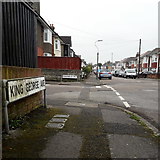
222. KING GEORGE AVENUE
The middle of three parallel monarchical avenues in Moordown, sandwiched between King Edward and Queen Mary Avenues. They comprise typical Moordown housing - decent detached houses from the reign of Edward and the Georges in the 20th century.
The middle of three parallel monarchical avenues in Moordown, sandwiched between King Edward and Queen Mary Avenues. They comprise typical Moordown housing - decent detached houses from the reign of Edward and the Georges in the 20th century.
223. KINGSBERE AVENUE
A steepish road descending from the main Kinson Road to Priestley Road, lined with bungalows typical of Ensbury Park and with a low hedge between pavement and roadway.
A steepish road descending from the main Kinson Road to Priestley Road, lined with bungalows typical of Ensbury Park and with a low hedge between pavement and roadway.
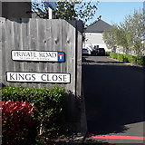
224. KINGS CLOSE
Modern infill development of which there are many examples in Ensbury Park. This particular part has been particularly densely infilled, with Kings Close backing onto Carter Close, Newmill Close and Orchard Close, all within the same section of original back gardens but none accessible from any of the others.
Modern infill development of which there are many examples in Ensbury Park. This particular part has been particularly densely infilled, with Kings Close backing onto Carter Close, Newmill Close and Orchard Close, all within the same section of original back gardens but none accessible from any of the others.
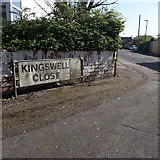
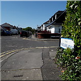
225. KINGSWELL CLOSE
One of three offshoots of Kingswell Road that share its first name, Gardens and Grove being the other two.
One of three offshoots of Kingswell Road that share its first name, Gardens and Grove being the other two.
226. KINGSWELL GARDENS
One of three offshoots of Kingswell Road that share its first name, Close and Grove being the other two.
One of three offshoots of Kingswell Road that share its first name, Close and Grove being the other two.
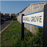
227. KINGSWELL GROVE
One of three offshoots of Kingswell Road that share its first name, Gardens and Close being the other two.
One of three offshoots of Kingswell Road that share its first name, Gardens and Close being the other two.
228. KINGSWELL ROAD
One of the more major minor roads in this area, if that's not a contradiction, Kingswell Road runs parallel with the main Columbia Road and is therefore relatively busy, feeding local side roads to the more major network. It is about ¾ mile in length and we see it here from its only substantial bend, about 10º or so.
The housing is varied but not much of it is as old as the cottage we see on the far left, which was the original farmhouse whose farmland was used for the development of this whole area from the 1930s.
229. KINSBOURNE AVENUE
Looking across the midway crossroads of this two-segment road, the junction with Beswick Avenue. It typifies the housing in this area, 1930s-50s houses with a few stretches of bungalows here and there.
Looking across the midway crossroads of this two-segment road, the junction with Beswick Avenue. It typifies the housing in this area, 1930s-50s houses with a few stretches of bungalows here and there.
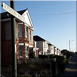
230. KINSON GROVE
Kinson Grove forms three sides of a largeish rectangle off Wimborne Road, with the resultant two 90º corners at the far end.
Here we look along it from the eastern end, with the telephone exchange on the corner.
Kinson Grove forms three sides of a largeish rectangle off Wimborne Road, with the resultant two 90º corners at the far end.
Here we look along it from the eastern end, with the telephone exchange on the corner.
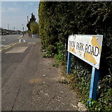
231. KINSON PARK ROAD
A road of reasonable length with bungalows on each side, more-or-less straight apart from the eastern segment which turns to meet New Road, providing a popular cut-through from Kinson and East Howe towards Ferndown.
A road of reasonable length with bungalows on each side, more-or-less straight apart from the eastern segment which turns to meet New Road, providing a popular cut-through from Kinson and East Howe towards Ferndown.
232. KINSON ROAD
One of the most important through roads in the area, it is surprising that Kinson Road has never been classified as at least a B road, but in the 98 years of road classifications it never has. The road forms the direct route from Wallisdown into the centre of Kinson, about 2 miles, and is dead straight for the southern two thirds of this journey. It is residential for its whole length, apart from a short shopping parade and a couple of other corner shops, and the house numbers reach the mid-400s at Kinson.
One of the most important through roads in the area, it is surprising that Kinson Road has never been classified as at least a B road, but in the 98 years of road classifications it never has. The road forms the direct route from Wallisdown into the centre of Kinson, about 2 miles, and is dead straight for the southern two thirds of this journey. It is residential for its whole length, apart from a short shopping parade and a couple of other corner shops, and the house numbers reach the mid-400s at Kinson.
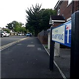
233. KITSCROFT ROAD
At the eastern end of Kinson's main shops is Kitscroft Road, a short cul-de-sac which leads to several other roads, all of whose only access is via here. From satellite images, the little development looks almost unfinished, with a number of rather abrupt dead ends that look as if there was once an intention that development go further. At the end of Kitscroft Road, there is access onto Duke's Coppice and that small detached part of Kinson Common, which remains public open space.
At the eastern end of Kinson's main shops is Kitscroft Road, a short cul-de-sac which leads to several other roads, all of whose only access is via here. From satellite images, the little development looks almost unfinished, with a number of rather abrupt dead ends that look as if there was once an intention that development go further. At the end of Kitscroft Road, there is access onto Duke's Coppice and that small detached part of Kinson Common, which remains public open space.
( Page < < prev 1 ... 5 6 7 8 9 10 11 12 next >> )