OS 50K Symbols - Water features
![Creative Commons Licence [Some Rights Reserved]](https://s1.geograph.org.uk/img/somerights20.gif)
Great Britain 1:50 000 Scale Colour Raster Mapping Extracts © Crown copyright Ordnance Survey. All Rights Reserved. Educational licence 100045616.
Contents
on Ordnance Survey 1:50,000 maps, with map extracts showing the symbols. On the maps a blue circle is on or near
the symbol. Use the mouse to move the pointer over the blue circle on a map to hide it.
Click on a thumbnail to see a page with a larger photo, other photo details, and a larger section of the
1:50,000 Ordnance Survey map.
The article Ordnance Survey Map Symbols
gives an introduction, and links to others in the set of articles.
Marsh or salting
Marsh SN1101 : Bridge on B4318 over stream through marshland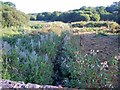 [smallmap SN 1110 0085]
 Salting SS8847 : Porlock Saltings
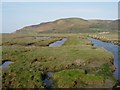 [smallmap SS 8845 4795]
 (also NO1919 : Downstream from Cairnie Pier, reed beds on mud)
 [smallmap NO 1990 1910]
River
NZ0914 : River Tees From Mortham
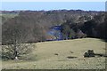 [smallmap NZ 0945 1445]
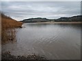
Lake
NY2031 : Bassenthwaite Lake & Skiddaw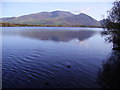 [smallmap NY 2049 3185]
Weir
SO9946 : River Avon at Fladbury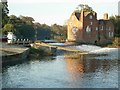 [smallmap SO 9975 4605]
Footbridge
TQ5144 : Footbridge over the River Eden near Penshurst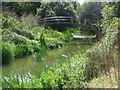 [smallmap TQ 5165 4455]
Bridge
ST6172 : River Avon, New Brislington Bridge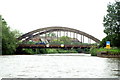 [smallmap ST 6165 7265]
Normal tidal limit
NO1026 : View across the Tay The "symbol" is in fact the end of the line along the river bank showing high water mark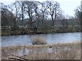 [smallmap NO 1039 2655]
 Ford
NH8638 : Grouse Beaters cross a ford on the River Findhorn. (with word "Ford"; symbol can be dashed or continuous lines with blue of water showing through)This does not seem to be consistent; some fords have the word "ford", others don't have the word "ford".
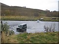 [smallmap NH 8600 3805]
Canal
NS8679 : Union Canal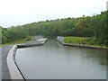 [smallmap NS 8665 7945]
 Aqueduct
SP1660 : Edstone Aqueduct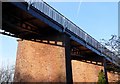 [smallmap SP 162 609] Here as in the OS key the aqueduct has a symbol like that for a railway viaduct. For an aqueduct with a symbol like a bridge see SJ3529 : The New Perry aqueduct on the Montgomery Canal.
 Towpath
NR8091 : Crinan Canal and Towpath Symbol shown on OS key is the same as a footpath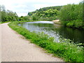 [smallmap NR 8090 9185]
 SO8583 : Towpath at Dunsley Though not indicated in the OS key, the towpath may also be shown with a public right of way symbol if appropriate - a footpath in this case.
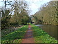 [smallmap SO 8545 8320]
 Lock
NS8981 : Lock at Bankside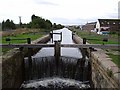 [smallmap NS 8970 8140]
Canal tunnel
SP6484 : Husbands Bosworth Tunnel (symbol not shown on OS key, it is same as road or rail tunnel)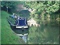 [smallmap SP 6419 8486]
Dry canal
SK6735 : The Grantham Canal at Cropwell Bishop, Nottinghamshire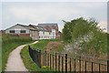 [smallmap SK 6785 3529]
Slopes
NZ4444 : Coastal Path near Easington Colliery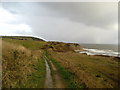 [smallmap NZ 4430 4475]
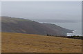
SX4348 : South Coast of Rame Peninsula
 [smallmap SX 4345 4885]
 Cliff
SS6086 : Snaple Point looking West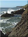 [smallmap SS 6045 8692]
 Flat rock
HY4853 : Dull Flag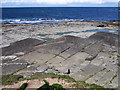 [smallmap HY 4885 5305]
Shingle
HY2904 : Low tide in Clestrain Sound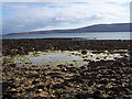 [smallmap HY 2975 0485]
Lighthouses
(in use)HY7855 : North Ronaldsay lighthouse and communications tower
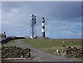 [smallmap HY 7840 5604]
(disused)
TM2530 : Disused lighthouse, Dovercourt, Essex
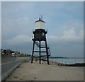 [smallmap TM 2525 3095]
Beacon
SX2150 : Polperro: beacon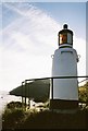 [smallmap SX 2130 5092]
High water mark
SD2708 : Formby beach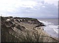 [smallmap SD 2705 0805]
 Low water mark
SS6389 : The tide is turningAlthough it is included in the OS list of symbols, there isn't an actual symbol -
it is shown by blue sea one side and one of the types of land, sand, mud or marsh the other side.
 [smallmap SS 6295 8975]
 Sand
(below high water)HY6739 : Peedie Sea, Sanday
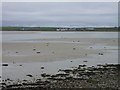 [smallmap HY 6765 3965]
 Dunes
(above high water)SD2809 : Behind the Foredunes
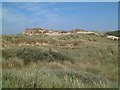 [smallmap SD 2815 0995]
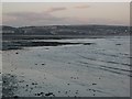
Mud
NO1919 : Downstream from Cairnie Pier [smallmap NO 1975 1915]
Great Britain 1:50 000 Scale Colour Raster Mapping Extracts © Crown copyright Ordnance Survey. All Rights Reserved. Educational licence 100045616.