SE0027
![Creative Commons Licence [Some Rights Reserved]](https://s1.geograph.org.uk/img/somerights20.gif)
Great Britain 1:50 000 Scale Colour Raster Mapping Extracts © Crown copyright Ordnance Survey. All Rights Reserved. Educational licence 100045616.
Contents
To see the browse page, the 1:25000 map in a popup window, or various other options click on 'Links for SE0027' and select the appropriate link.
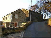
Burlees Lane and Raw Lane
Two rural unadopted streets that give access to two rows of farms and houses along the upper part of the northern side of the Calder Valley.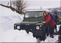
Living in the countryside off the public highway network is peaceful, but has occasional disadvantages!
Wadsworth Lane and Height Road
This is part of an ancient route from Halifax to Lancashire via Luddenden, Midgley, Hebden Bridge and Heptonstall.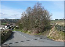
Wadsworth Lane leads down to the Dodd Naze housing estate and Hebden Bridge town centre, whilst Rowland Lane is a bridleway to Chiserley. In the centre a triangular wood has seats and makes a pleasant place for a picnic. This was Butts Delf (sandstone quarry) on the 1850 map. On the horizon there is the mill at Chiserley on the right, and Heptonstall church tower on the left.
by Humphrey Bolton
The woodland is the site of Butts Delf, a sandstone quarry shown on the 1850 map.
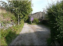
This is Rowland Lane. Old Town Mill can be seen in the distance.
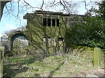
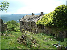
Climbing the hill eastwards, we come to a derelict house with attached cottage and scant remains of a barn.
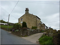
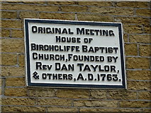
Further up the hill, we pass a house that was used for Baptist meetings in the 18C - see next image.
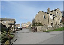
Then there is a recent housing development next to Saughes Farm.
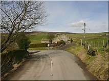
At the top of the hill there is a road junction with an old guidestone. Neither have been geographed yet. The left turn is Height Road and leads to Chisley ('Chiserley' on current OS maps), Old Town and on to join the Keighley road at Pecket Well. The house next to the junction was the Mount Skip Inn.
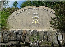
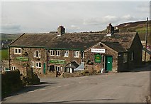
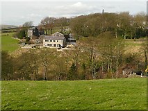
The road eastwards to Midgley is also Height Road. It passes the Hebden Bridge Golf Club course.
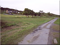
The clubhouse is in Great Mount, shown on the 1850 map and presumably originally a farm. There are extensive disused sandstone quarries on Cock Hill behind the building.
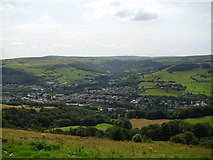
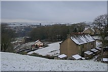
Height Road runs along the edge of the moor, allowing fine views to the south over Calderdale towards the hills on the south side. The town in the centre of this shot is Mytholmroyd.
by Gordon Hatton
Mount Skip to Chiserley
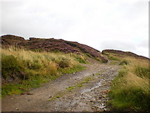
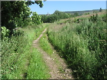
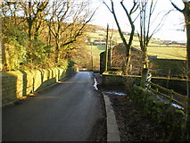
This is one of the old quarry tracks, now public footpaths, off Height Road.
The road layout, with sudden bends such as this one, suggests that there was a network of unsurfaced lanes, footpaths or packhorse tracks of which only a few became public roads. The track straight on is Dike Lane, and at the bend the road name changes from Height Road to Nook Lane,
The grid lines goes through the next road junction, with Lane Ends Lane, and through the Hare and Hounds public house.
Lane Ends Lane and Sandy Gate Lane
This lane passes houses seemingly placed at random on the outskirts of Chiserley, which was originally a just few houses around Chisley Hall but became a small village when a housing estate was built. For some reason the name was changed to Chiserley.
At the end of Lane Ends Lane, Walker Lane goes off northwards through Chiserley to Old Town, passing Ibbot Royd Farm.
From the road junction, road to the west, towards Hebden Bridge, is Sandy gate Lane although formerly called Ibbot Royd Lane. There is a view across Ibbot Royd Clough to Ibbot Royd, where there is a modern house in front of the barn, and a large 19C house. The chimney of Old Town Mill is on the skyline.
Links to old maps
Link to old OS six-inch maps on the Calderdale Council websiteSearch for Rowland Farm and choose any of the houses from the list. You can adjust the zoom level and change instantly between four editions of the OS six-inch map from 1851-5 to 1934-48.
Link to old OS 1:2500 maps
Enter the all-figure grid co-ordinates at the centre of the area you wish to see. The window for 1:2500 maps is approximately 970m wide by 680m high. You cannot pan the maps, but have to re-enter new co-ordinates and wait for the map to reload.
Bibliography
Colin Spencer,The History of Hebden Bridge, Hebden Bridge Literary & Scientific Soc. 1991ed. Bernard Jennings, Pennine Valley - a history of upper Calderale, Otley, 1994
Great Britain 1:50 000 Scale Colour Raster Mapping Extracts © Crown copyright Ordnance Survey. All Rights Reserved. Educational licence 100045616.