Circular Walk to and from Ardbeg, via Solam, Loch Uigeadail and Tighnaspeur, Islay
The walk started from the phone box at Ardbeg, along the track to Airigh nam Beist and then northwest to Solam, rather than northeast to Loch Iarnan as on a previous walk. Solam is known as the plague village on Islay because it is where plague victims were banished to keep them away from healthy Islay residents 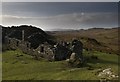 . I have yet to find the carved faces, flat stone and wishing well mentioned by Armin Grewe in his blog: Link
![]() .
.
The track continues northwards from here and is quite well-defined, until you realise THAT track is actually going up Beinn Sholum. The one marked on the map does not seem to exist. Before ascending Beinn Sholum, however, the track fords a burn 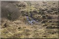 - there are numerous unnamed burns in this part of the island. I wanted to follow the track because, according to the map, it wanders in and out of five grid squares and I wanted to cover them all. I checked the GPS constantly to keep track of where I was whilst 'nimbly' hopping across bog after bog and trying to hold on to camera, walking stick and bicoculars. Basically I skirted the bottom of Beinn Sholum
 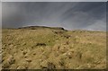 via this vague track
 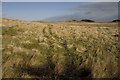 and
and 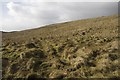 , heading for the valley between Beinn Sholum and Leacann a' Chnoic (The broad side of the hill)
 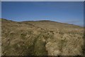 and
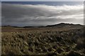
and 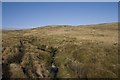 . I had chosen today for walking as the forecast showed it was going to be the best of a mixed bag of weather - it was! I kept stopping to look back and admire the scenery
 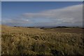 ,
,  and
and 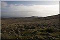
I joined the burn which flows from Loch Uigeadail, but again appears to have no name, despite being quite a full force 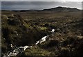 and
and 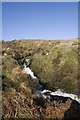 . If I wasn't geographing I wouldn't have stopped quite as often to take photos as the views are quite repetitive until you reach Loch Uigeadail - and I was very relieved to do so. I ended up reaching its western corner
 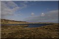 , instead of its southerly point (where the track shown on the map leads to). A pair of Mallards flew off on my approach, otherwise the Loch was empty - as was the air. Large herds of Red Deer were my only sign of wildlife on this walk, with the exception of two Snipe and a few Ravens.
I looked for somewhere sheltered to eat lunch, but there was nowhere obvious as I continued walking eastwards, desperate now for food and rest. There is a sluice at the most southerly point of the Loch, which leads into the burn I had followed for some of the way 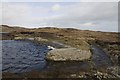 . I followed the burn south for a bit and then plonked on the grass to eat my lunch before crossing the burn and continuing NNW towards Tighnaspeur. NR4150 is a pretty featureless gridsquare
 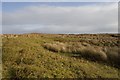 and
and 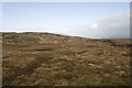 . I relied on the GPS to keep me straight. I kept thinking I was heading south, only to find I was actually heading north - albeit by a few degrees. At least this meant I unintentionally dipped into another gridsquare! -
 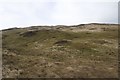 A boulder here makes an attractive feature for a photograph -
 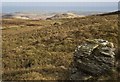 .
.
I came upon Tighnaspeur (Sky House) suddenly; I was directly above it 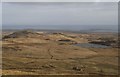 Halleluja! I had expected to see it as a tiny dot in the distance, feel my heart sink and then trudge towards it - so this was a pleasant surprise. What stunning views the residents of this tiny cottage once enjoyed. Surprisingly part of this ruin is still roofed. Perhaps it is used for storage for fishermen or gamekeepers? To the east I could see the twin fortified heights of An Dun and Dun Beag across Loch nan Clach (Loch of the Stone). I spent some time investigating this erstwhile home
 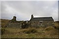 , finding the fireplace still quite intact
 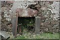 . There appeared to be rusty old bed springs still dotted around the main living quarters too.
My walk was far from over, however, and I had to press on. Leaving this poignant scene behind me, I headed south, passing Loch nan Clach 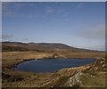 and
and 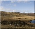 and a distant view of Loch Carn a' Mhaoil -
 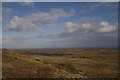 . Knowing it would only obtain supplementary status I photographed the loch anyway and continued southwestwards, putting off having to scale a deer fence. Eventually I found a suitable place to cross and did so with care.
The terrain here is fascinating - a line of rocky outcrops runs NE -SW for about two and a half miles, and within these outcrops are concealed (or not so concealed) hut circles, duns and enclosures. The outcrops were easy enough to find 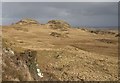 and
and 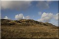 , but I could not find the hut circles, despite having the GPS. Time was not on my side so I did not spend long looking, making up my mind to return with that aim in view and not being sidetracked by geographing!
Passing through more boggy grassland 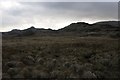 and with a view of a distant waterfall
 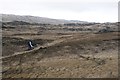 I eventually came across the Ardilistry River
 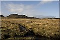 - finally a river/burn with a name! I did not follow the river, choosing instead to head for Loch Iarnan from where I knew there was a track back to the car at Ardbeg.
The walk was about 8 miles in total, although it's difficult to measure when zigzagging such a lot and trudging across such difficult and boggy terrain. The highlights were undoubtedly the picturesque Tighnaspeur and the fascinating dinosaur-like dun-land of this south-eastern corner of Islay.
- When
- Sun, 26 Feb 2012 at 07:44
- Grid Square
 NR4050
blog comments powered by Disqus