2007
SO0307 : Pont y Cafnau iron rail bridge and aqueduct (1793)
taken 17 years ago, near to Cefn-Coed-y-Cymmer, Merthyr Tydfil/Merthyr Tudful, Wales
This is 1 of 3 images, with title Pont y Cafnau iron rail bridge and aqueduct (1793) in this square
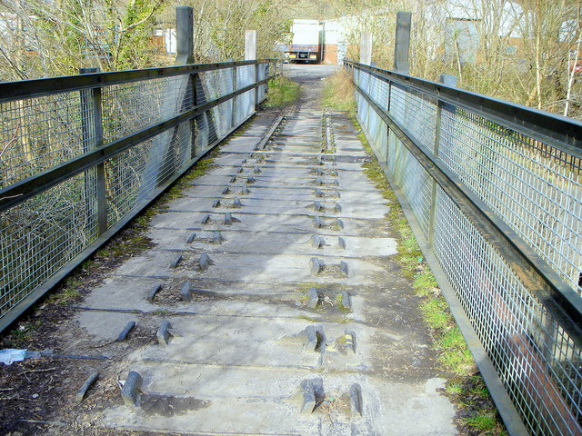
Pont y Cafnau iron rail bridge and aqueduct (1793)
The Pont y Cafnau iron bridge has been acknowledged as the world's oldest surviving iron railway bridge [ - see Context for World Heritage Bridges
A joint publication with TICCIH, 1996, By Eric DeLony Link (Archive Link ) ; and Hague, D and Hughes, S - Pont Y Cafnau, the first iron railway bridge and aqueduct? - Ass. Industrial Archaeology Bulletin, 1982, 9, No4, 3-4 ].
The Pont y Cafnau bridge is located just below the confluence of the Afon Taf Fawr and the Afon Taf Fechan rivers; it is used as a public footpath and may be used to cross the river and connect the Taff Trail waymarked path with the nearby Cyfarthfa Castle.
This is a unique cast-iron bridge, a two-deck combined aqueduct and tramroad bridge built by the chief engineer of the Cyfarthfa ironworks, to carry both the works' tram line from the nearby limestone quarries at Gurnos and its water supply over the river. Its diminutive scale notwithstanding, this was an important early prototype for iron bridge construction that influenced Telford's monumental feats of engineering such as the celebrated Pontcysyllte and Chirk aqueducts. [ See The International Canal Monuments List, and. Link (Archive Link ) ]
A joint publication with TICCIH, 1996, By Eric DeLony Link
The Pont y Cafnau bridge is located just below the confluence of the Afon Taf Fawr and the Afon Taf Fechan rivers; it is used as a public footpath and may be used to cross the river and connect the Taff Trail waymarked path with the nearby Cyfarthfa Castle.
This is a unique cast-iron bridge, a two-deck combined aqueduct and tramroad bridge built by the chief engineer of the Cyfarthfa ironworks, to carry both the works' tram line from the nearby limestone quarries at Gurnos and its water supply over the river. Its diminutive scale notwithstanding, this was an important early prototype for iron bridge construction that influenced Telford's monumental feats of engineering such as the celebrated Pontcysyllte and Chirk aqueducts. [ See The International Canal Monuments List, and. Link
 Map © Crown Copyright")
TIP: Click the map for more Large scale mapping
- Grid Square
- SO0307, 103 images (more nearby 🔍)
- Photographer
- John Wilson (more nearby)
- Date Taken
- Friday, 9 March, 2007 (more nearby)
- Submitted
- Sunday, 26 October, 2008
- Subject Location
-
OSGB36:
 SO 037 071 [100m precision]
WGS84: 51:45.2790N 3:23.7573W - Camera Location
-
OSGB36: SO 037 071
- View Direction
- Northeast (about 45 degrees)