J2923 : Mourne Wall, Slievenaglogh
taken 15 years ago, 4 km NNE of Attical, Co Down, Northern Ireland
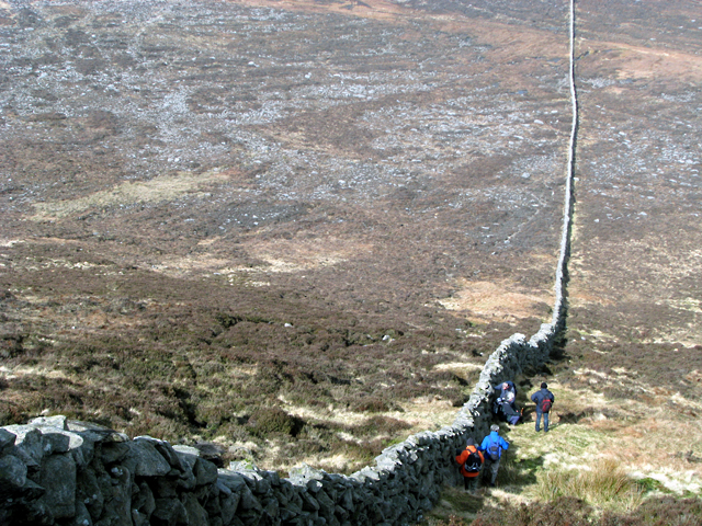
This is the view of the wall on the northern descent. From here the wall crosses the Banns Road before ascending on towards Slieve Muck.
The wall also provides an excellent windbreak during the lunch stop - winds here were gusting to approximately 60mph.
The Mourne Wall is a 22 mile long wall in the Mourne Mountains. It was built between 1904 and 1922 by the Belfast Water Commissioners to enclose their catchment areas in the Mournes and protect the area from the effects of cattle and sheep on the water course Link
. The wall is predominately constructed from local granite using traditional dry stone walling techniques; on average the wall is about 1.5 metres high and 0.8 to 0.9 metres thick. It is not uniform in construction along the entire length - the 'classic' granite wall is only to be found north of Carn mountain and Long Seefin with particularly impressive sections on Slieve Commedagh and Slieve Donard; elsewhere it largely resembles the traditional dry stone walls found elsewhere in the Mournes and south County Down. In places, such as Slieve Muck, the wall is not constructed of granite at all.
![Creative Commons Licence [Some Rights Reserved]](https://s1.geograph.org.uk/img/somerights20.gif)
|
· Find out How to reuse this image ·
Share:
|
|||||
| Start a discussion on J2923 | Suggest an update to this image | Contact the contributor | |||
- Grid Square
- J2923, 28 images (more nearby
 )
)
- Photographer
- Rossographer (find more nearby)
- Date Taken
- Saturday, 14 March, 2009 (more nearby)
- Submitted
- Monday, 16 March, 2009
- Category
- Dry stone wall (more nearby)
- Subject Location
-
Irish:
 J 297 233 [100m precision]
WGS84: 54:8.5604N 6:0.9620W - Camera Location
-
Irish: J 297 232
- View Direction
- Northwest (about 315 degrees)