2009
SK2854 : Wirksworth Station, Ecclesbourne Valley Railway
taken 15 years ago, near to Wirksworth, Derbyshire, England
This is 1 of 8 images, with title starting with Wirksworth Station in this square
Wirksworth Station, Ecclesbourne Valley Railway
Wirksworth station is the major destination on the Ecclesbourne Valley Railway. The station originally lost its passenger services in June 1947 when they were suspended due to post-war fuel shortages, closure becoming final in 1949. The station yard continued in use for freight purposes into the late 1960s when it became a stone terminal for the limestone traffic originating from local quarries. The final freight service under British Railways ran in December 1989. Part of the station yard at Wirksworth is still a strategic freight site designated by Network rail. This means development in this area is under strict regulation.
The railway became the Ecclesbourne Valley Railway in 2002 when Wirksworth Station was ceremonially reopened. Funding for the lines reopening came from the owning company Wyvern rail Plc who launched a successful share appeal. The first passenger services to Gorsey Bank (1/2 mile south) ran in August 2004, with services north to Ravenstor (1/2 mile north) commencing in September 2005 and a more extensive service to Idridgehay (4 miles south) commencing March 2008. It is planned to reopen to the main line junction at Duffield by October 2010. Funding for the extension was granted recently by the East Midlands Development agency who gave £208,000 to refurbish the line.
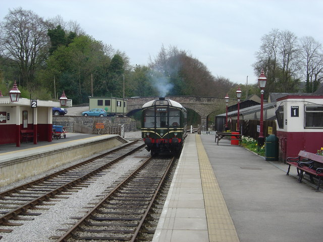
In this view, we see a vintage railcar standing at Platform 1,which is the original platform rebuilt to modern standards. The platform to the left, platform 2 was built by volunteers to support the Idridgehay service, while beyond, Platform 3 (also a new addition) serves the branch to Ravenstor.
The railway became the Ecclesbourne Valley Railway in 2002 when Wirksworth Station was ceremonially reopened. Funding for the lines reopening came from the owning company Wyvern rail Plc who launched a successful share appeal. The first passenger services to Gorsey Bank (1/2 mile south) ran in August 2004, with services north to Ravenstor (1/2 mile north) commencing in September 2005 and a more extensive service to Idridgehay (4 miles south) commencing March 2008. It is planned to reopen to the main line junction at Duffield by October 2010. Funding for the extension was granted recently by the East Midlands Development agency who gave £208,000 to refurbish the line.
In this view, we see a vintage railcar standing at Platform 1,which is the original platform rebuilt to modern standards. The platform to the left, platform 2 was built by volunteers to support the Idridgehay service, while beyond, Platform 3 (also a new addition) serves the branch to Ravenstor.
 Map © Crown Copyright")
TIP: Click the map for more Large scale mapping
- Grid Square
- SK2854, 312 images (more nearby 🔍)
- Photographer
- Neil Ferguson-Lee (more nearby)
- Date Taken
- Sunday, 12 April, 2009 (more nearby)
- Submitted
- Monday, 13 April, 2009
- Subject Location
-
OSGB36:
 SK 289 540 [100m precision]
WGS84: 53:4.9518N 1:34.1287W - Camera Location
-
OSGB36: SK 289 541
- View Direction
- SOUTH (about 180 degrees)