J3475 : Cleared land, Belfast (2)
taken 15 years ago, near to Belfast, Co Antrim, Northern Ireland
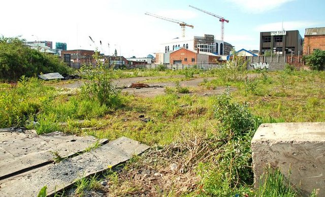
The grade-separated junction at York Street J3475 : The Westlink, York Street, Belfast and J3475 : The M2, York Street, Belfast where the Westlink would join the M2 (to the north) and the M3 (to the east) remains un-built but the (very expensive) idea has been revived. This is part of the land (looking from Gt Georges Street to the Dunbar Link). The cranes are at the Encore site J3474 : The "Encore" building, Belfast (3).
A long-vacant site, off York Street, for which there was, in June 2011, an application for planning permission 0737/O Vacant site at Nelson Street, bounded by Great Georges Street to north, Little York Street to west, Nelson Street to east and other lands adjacent to Little Patrick Street to south. Site for social housing development. Note: this description and the photographs submitted by me appear as a matter of record only and should not be interpreted as expressing any opinion for or against the application.
This site and the proposals attracted considerable comment and opposition. Leaving out the long bit in the middle, the application went before the Planning Appeals Commission in default of a decision on an application for outline planning permission. On 22 May 2013 the Commissioner decided Subject to the various conditions I have mentioned, there is no sound technical reason for withholding planning permission. There are 17 conditions full details of which may be seen here Link.
The Westlink (opened in two stages in 1981 and 1983 and upgraded in 2008) was meant to connect the M1 and M2 motorways bypassing the centre of Belfast. Despite various proposals over the years the road and the M2 remain unconnected. Access to the latter is by means of an at grade crossing, controlled by traffic lights, at York Street. The M3, between the Sydenham bypass and the M2 (completed in 1998) although close to the Westlink at Nelson Street remains unconnected.
There are plans (unlikely to be completed in my lifetime) to build grade-separated connecting roads (using underpasses rather than elevated roads as envisaged when the Westlink opened). If the scheme proceeds (remembering that NI road schemes are rarely completed as planned) it will probably be the most expensive undertaken here.
The photographs submitted by me appear as a matter of geographical and historical record only. I have no connection with the Roads Service or any campaign for or against the proposed scheme.
This is a useful unofficial link Link
![Creative Commons Licence [Some Rights Reserved]](https://s1.geograph.org.uk/img/somerights20.gif)
|
· Find out How to reuse this image ·
Share:
|
|||||
| Start a discussion on J3475 | Suggest an update to this image | Contact the contributor | |||
- Grid Square
- J3475, 773 images (more nearby
 )
)
- Photographer
- Albert Bridge (find more nearby)
- Date Taken
- Sunday, 24 May, 2009 (more nearby)
- Submitted
- Monday, 25 May, 2009
- Category
- Land > Vacant sites (more nearby)
- Subject Location
-
Irish:
 J 340 750 [100m precision]
WGS84: 54:36.3472N 5:55.5557W - Camera Location
-
Irish: J 341 750
- View Direction
- West-southwest (about 247 degrees)