J3471 : "The Embankment", Belfast (1)
taken 15 years ago, 3 km from Belfast, Co Antrim, Northern Ireland
"The Embankment", Belfast (1)
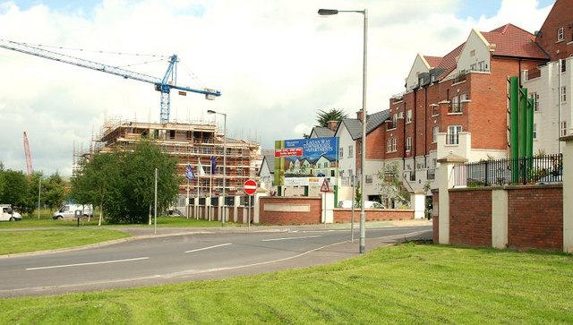
Two developments along the Annadale Embankment The Embankment apartments (at the crane) under construction and Lagan Way apartments and town houses on the right.
"The Embankment" development, Annadale Embankment, Belfast
A large-scale development of apartment and houses on the eastern side of the Annadale Embankment. Work stopped when an administrator was appointed to the development group in May 2011.
Work restarted, with a new developer, in 2017.
![Creative Commons Licence [Some Rights Reserved]](https://s1.geograph.org.uk/img/somerights20.gif)
|
· Find out How to reuse this image ·
Share:
|
|||||
| Start a discussion on J3471 | Suggest an update to this image | Contact the contributor | |||
Loading map... (JavaScript required)
- Grid Square
- J3471, 273 images (more nearby
 )
)
- Photographer
- Albert Bridge (find more nearby)
- Date Taken
- Friday, 5 June, 2009 (more nearby)
- Submitted
- Friday, 5 June, 2009
- Category
- Building site (more nearby)
- Subject Location
-
Irish:
 J 341 713 [100m precision]
WGS84: 54:34.3428N 5:55.6204W - Camera Location
-
Irish: J 342 711
- View Direction
- Northwest (about 315 degrees)
Image classification(about):
Geograph
This page has been viewed about 139 times.
View this location:
KML (Google Earth) ·
Google Maps ·
Bing Maps ·
Geograph Coverage Map ·
More Links for this image
·
Bing Maps ·
Geograph Coverage Map ·
More Links for this image