J3472 : Derelict building near Queen's University, Belfast
taken 15 years ago, near to Belfast, Co Antrim, Northern Ireland
Derelict building near Queen's University, Belfast
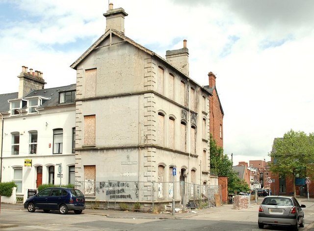
Forlorn, fenced and derelict property at the corner of Magdala Street (left) and the Sandhurst Road. It might once have been Granville House, the home of one John Craig a maker of packing cases. If anyone has a definitive answer Id be pleased to know. J3472 : Building under renovation, Belfast shows the building under renovation and J3472 : No1 Sandhurst Road, Belfast (September 2013) shows it after renovation and conversion to apartments..
![Creative Commons Licence [Some Rights Reserved]](https://s1.geograph.org.uk/img/somerights20.gif)
|
· Find out How to reuse this image ·
Share:
|
|||||
| Start a discussion on J3472 | Suggest an update to this image | Contact the contributor | |||
Loading map... (JavaScript required)
- Grid Square
- J3472, 419 images (more nearby
 )
)
- Photographer
- Albert Bridge (find more nearby)
- Date Taken
- Sunday, 14 June, 2009 (more nearby)
- Submitted
- Tuesday, 16 June, 2009
- Geographical Context
- Place (from Tags)
- Category
- Buildings > Building (derelict) (more nearby)
- Subject Location
-
Irish:
 J 340 728 [100m precision]
WGS84: 54:35.1571N 5:55.6348W - Camera Location
-
Irish: J 340 728
- View Direction
- Northwest (about 315 degrees)
Other Tags
Image classification(about):
Geograph
This page has been viewed about 161 times.
View this location:
KML (Google Earth) ·
Google Maps ·
Bing Maps ·
Geograph Coverage Map ·
More Links for this image
·
Bing Maps ·
Geograph Coverage Map ·
More Links for this image